
Even as a heavy winter storm moves out of the Chicago area, there are still wide-ranging impacts being felt across the region.
Here is a recap of our live blog, with headlines throughout the day.
After Winter Storm Hammered Chicago Area, Windy Conditions and More Snow Possible Friday
Heavy snow that pounded the Chicago area and northwest Indiana on Thursday is finally beginning to taper off across the area, but more snow and gusty winds are in the forecast for Friday.
Feeling out of the loop? We'll catch you up on the Chicago news you need to know. Sign up for the weekly Chicago Catch-Up newsletter here.
Before that front arrives in the afternoon and evening, crews will continue to clean up from a heavy snow storm that dumped as much as six inches or more of snow in Illinois, along with at least eight inches of snow in parts of northwest Indiana.
To make matters worse, the snow fell quickly, sometimes more than an inch an hour, causing massive traffic issues, including a pile-up that involved more than two dozen vehicles in Woodford County on Interstate 39.
While a dozen tow trucks continue to clean up that wreck, which miraculously left no one injured, another round of wind and snow is expected to hit as a cold-front moves through the region on Friday afternoon and into the evening.
Local
Blowing snow could cause more travel issues Friday, especially in rural communities, and as a result several school districts across the region have already moved to e-learning for Friday.
When the front finishes moving through, it will leave colder temperatures behind it, albeit briefly. Temperatures Saturday are only expected to rise into the 20s, but much warmer conditions are expected for Sunday, with highs potentially approaching 50 degrees in many locations.
9:39 p.m.: Flooding Causing Issues Throughout Illinois, Indiana
A flood warning has been issued for several different rivers after heavy rain and snow in the last few days.
A flood warning is now in effect for LaSalle County, with the Vermilion River expected to experience minor flooding in coming days.
A flood warning was also issued for several locations along the Iroquois River, including in Jasper County near Rensselaer and in Newton County near Foresman.
The river could also hit flood stage in the communities of Iroquois and Chebanse in Illinois.
Finally, a river flood warning was also issued for Ottawa, with the Illinois River potnetially hitting flood stage Friday afternoon.
A flash flood watch also remains in effect for Grundy and southern Will counties, impacting the communities of Channahon, Wilmington, Minooka, Morris, Coal City and Manhattan.
That watch impacts the Kankakee River, with ice jams still potentially breaking along the length of the river.
A flood watch is also in effect for Jasper and Porter counties, with the Kankakee River potentially rising to flood stage in coming days. The river could also hit flood stage in Lake and Newton counties as well, officials said, but whether the water will rise enough to hit that level remains unclear at this time.
9:08 p.m.: Winter Storm Warning Expires for Most Areas
A winter storm warning has been allowed to expire in most of the NBC 5 viewing area, as a powerful storm system moves its way largely out of the region.
The warning has now expired for Grundy, Kankakee and Will counties in Illinois.
A winter weather advisory was also allowed to expire in DuPage, Kendall, Cook and Will counties in Illinois.
The warning was extended in several Indiana counties however, including Lake, Newton and Jasper counties. Snow will continue to fall in those areas through midnight, with additional accumulations of an inch or more possible.
A winter storm warning also remains in effect for Porter County until midnight, with additional accumulations of 2-to-4 inches possible.
8:58 p.m.: Illinois Schools Announce Closures, Moves to Remote Learning Due to Blowing Snow Friday
NOTE: For the most up-to-date list of school closures and moves to remote learning, viewers can search the Emergency Closing Center website throughout the night.
Although a powerful storm system that dumped six or more inches of snow in some locations will have moved out of the area by Friday morning, some schools will once again switch to remote learning, or close entirely, due to the threat of blowing snow.
Wind gusts in excess of 40 miles per hour are expected in some locations that were hit hard by snow on Thursday, leading officials to announce that they will either cancel classes, or switch to remote-instruction days.
Numerous schools in Kankakee County are among those impacted, including Bourbonnais Elementary School District 53, which will close completely on Friday.
Officials say that the school’s bylaws do not allow for back-to-back e-learning days due to weather, and therefore they will use one of their inclement weather days instead.
School districts in nearby Kankakee, Bradley and Manteno will all switch to remote learning on Friday, as will Momence, according to officials.
8:31 p.m.: Nearly 700 Flights Canceled at Chicago Airports
The latest update from the Chicago Department of Aviation indicates that 685 flights have been canceled at city airports because of Thursday's weather.
At O'Hare, 521 flights have been canceled, with an average flight delay of nearly 90 minutes.
At Midway, flights are being delayed by under 15 minutes, but a total of 164 flights have been canceled at the airport.
7:37 p.m.: Officials Report 6 Inches or More of Snow in Some Locations as Storm Moves Out of Area
Some locations in northern Illinois are seeing snowfall wrap up for the evening, but not before significant accumulations occurred.
In Streator, located in LaSalle County, six inches of snow fell during Thursday's storm.
In Joliet, 3.6 inches of snow were reported, and in Chatwsorth, four inches of snow fell.
We will continue to update snowfall totals here for the remainder of the evening.
7:09 p.m.: Winter Storm Warning Remains in Effect for Most of Area
A winter weather advisory that was in effect for DeKalb, Kane and LaSalle counties was canceled, as snow is ending across the area Thursday evening.
Motorists are being advised to continue using caution as crews continue to clean up roadways.
A winter storm warning will remain in effect for Grundy, Will and Kankakee counties in Illinois, along with Lake, Newton and Jasper counties in Indiana, until 9 p.m.
The winter storm warning will also remain in effect through midnight in Porter County, with heavy snow continuing to fall in that part of the area.
A winter weather advisory is still in effect in DuPage, Kendall, Cook and Will counties until 9 p.m.
6:58 p.m.: Interstate 39 to Remain Closed for 12 Hours After Winter Storm Causes Pileup of More Than 100 Vehicles
Illinois State Police say that Interstate 39 between Normal and Minonk will remain closed for approximately 12 hours after multiple crashes involving more than 100 vehicles were reported on the roadway.
According to authorities, the southbound lanes will remain closed throughout the night as crews clean up debris and plow snow from the roadway.
"We are diligently working to ensure motorists are safely escorted from the area to warming centers," ISP said in a statement.
The crash occurred in Woodford County in the community of El Paso. Officials say that all southbound lanes of Interstate 39 were shut down, with traffic diverted off at exit 14.
5:47 p.m.: Over 600 Flights Canceled at O'Hare, Midway Airports Due to Winter Storm
Over 600 flights at Chicago's O'Hare and Midway airports have been canceled Thursday due to heavy snow and gusty winds in the area.
As of Thursday at 5:46 p.m., 445 flights were canceled at O'Hare and 161 at Midway, according to the Chicago Department of Aviation.
Average delays of more than an hour are being reported at O'Hare, while delays of 30 minutes are being reported at Midway.
5:37 p.m.: Chicago Snowfall Totals: The Latest Snow Accumulation Reports From Across the Area
Snowfall totals are beginning to come in from around the state of Illinois, with several communities already seeing four or more inches of snow accumulation in a matter of hours.
According to the National Weather Service, more than five inches of snow have already fallen in Bradley, located in Kankakee County.
The city of Kankakee has already reported more than four inches of snow in just over four hours, while Bourbonnais has reported four inches of accumulation.
In Plainfield, only 2.4 inches of snow have fallen, but 1.4 inches fell within the span of an hour during the afternoon, officials said.
You can find the most up-to-date totals here.
5:13 p.m.: Joliet Utilizing 'Alternative Response Plan' Amid Heavy Snowfall
Police in suburban Joliet are asking residents not to travel at this time, and are urging motorists involved in minor traffic collisions to exchange information and to report crashes to authorities at a later date.
5:11 p.m.: Massive Pileup, Involving Approximately 100 Vehicles, Reported in Central Illinois Amid Whiteout Conditions
Illinois State Police urged motorists to stay off roads Thursday after as much as 4 inches (10.16 centimeters) of wind-blown snow led to whiteout conditions and multiple pileups, including one in Woodford County that police say may have involved more than 100 vehicles.
The Illinois Department of Transportation closed Interstate 39 north of Bloomington Thursday afternoon after police said a pileup several hundred yards (meters) long involving approximately 100 vehicles.
The crash occurred in Woodford County in the community of El Paso. Officials say that all lanes of Interstate 39 were shut down, with traffic diverted off at exit 14.
Several other area highways were experiencing significant issues, including I-74 eastbound near Champaign which was completely blocked for a while after a crash involving several jack-knifed semitrailers, police said.
4:33 p.m.: Illinois Road Conditions Map: Check Conditions as Heavy Snow Continues to Fall
Treacherous travel conditions causing a domino-effect of major crashes and expressway jams Thursday prompted the Illinois State Police to activate its "emergency snow plan" for Cook County as heavy snow continues to fall across the Chicago area.
Motorists are being asked to stay off area roadways unless absolutely necessary.
You can check the latest road conditions here.
4:29 p.m.: Flash Flood Warning Issued as Ice Jam Breaks on Kankakee River
The National Weather Service has issued a flash flood warning for east-central Grundy County and west-central Will County after an ice jam on the Kankakee River broke open near Interstate 55.
At approximately 4:23 p.m., emergency management officials and river gauges confirmed that the jam, located downstream of Wilmington near Interstate 55, has broken, causing flash flooding downstream.
Authorities say that rapid-onset flooding is already occurring, and individuals who live near the river, creeks and drainage ditches should take immediate precautions.
4:21 p.m.: IDOT Reports Crashes on I-57, I-80
Crashes continue to pile up on area roadways, with traffic backups being reported across the region.
In Cook County, a crash near 127th Street in suburban Calumet Park is snarling traffic on the northbound side of Interstate 57:
On Interstate 80 near suburban Mokena, a pair of crashes near 187th Street are blocking the leftbound lane of Interstate 80, causing delays in that area as well:
South of the NBC 5 viewing area, multiple jack-knifed semis are currently blocking eastbound Interstate 74 approximately 15 miles to the west of Champaign, causing massive traffic issues.
Authorities are "highly discouraging" travel in those areas at this time.
4:16 p.m.: Over 500 Flights Canceled at O'Hare, Midway Airports Due to Winter Storm
Over 500 flights at Chicago's O'Hare and Midway airports have been canceled Thursday due to heavy snow and gusty winds in the area.
As of Thursday at 4:11 p.m., 365 flights were canceled at O'Hare and 142 at Midway, according to the Chicago Department of Aviation.
3:49 p.m.: ISP Puts 'Emergency Snow Plan' in Effect in Cook County, to Limit Responses to Only 'Significant Crashes'
Illinois State Police in Chicago have activated their “emergency snow plan” for Cook County, saying that they will only respond to significant crashes and stranded motorists in the coming hours as heavy snow continues to fall across the area.
According to a Facebook post, the plan went into effect at 3:20 p.m., and includes a “no tow” order, which means that vehicles that are stuck in ditches or on shoulders will not be towed until conditions improve.
Stranded motorists will still be transported to safe locations, but their vehicles will not be immediately towed away, police said.
3:24 p.m.: Indiana State Police Tell Drivers to Stay Off Interstate 65
Indiana State Police are ordering motorists to stay off of Interstate 65 near mile marker 235, as several crashes are causing serious issues on the roadway.
According to authorities, the southbound side fo the roadway is closed bewteen State Road 2 and State Road 10 due to a multi-vehicle pile-up, and motorists are being urged to stay off roadways in the area.
In addition, troopers are urging stranded motorists not to call 911, because an influx of calls is causing phone lines to be tied up.
1:38 p.m.: Crashes Close Parts of Several Illinois and Indiana Interstates
Several area interstates are closed due to crashes amid an ongoing winter storm that is continuing to intensify on Thursday afternoon.
According to the Indiana State Police, the southbound side of Interstate 65 is currently closed near mile marker 235, near the Kankakee River bridge, due to an accident. Lanes are blocked between State Road 2 and State Road 10, according to officials.
The northbound lanes in the vicinity are also experiencing gaper’s delays, as well as delays because of the heavy snow and gusty winds in the area.
The southbound lanes of Interstate 55 are also closed near mile marker 231 because of a crash, according to Illinois State Police.
In the city of Chicago, stop-and-go traffic is being reported on the Dan Ryan Expressway, as well as the Eisenhower, because of hazardous travel conditions.
Read more here.
12:14 p.m.: Multiple Accidents Reported in Kankakee County
Multiple accidents were reported in Kankakee County, according to the Sheriff's Office, as a winter storm moves through the area.
Following reports of vehicles sliding off the road, officials warned motorists to slow down and drive safely Thursday afternoon.
9:20 a.m.: Chicago-Area to Likely Remain Dry Until Late Morning Snow Arrives
After remaining dry since about 5 a.m., round two of the winter storm system is set to bring snow showers to the Chicago area by late morning and will continue through the afternoon.
According to the NBC 5 Storm Team, some areas could see heavy rainfall this afternoon, with rates up to an inch or more falling per hour. Strong winds will likely produce blowing snow, which could reduce visibilities.
9:00 a.m.: Over 300 Flights Canceled at O'Hare, Midway Airports Due to Winter Storm
Over 300 flights at Chicago's O'Hare and Midway airports have been canceled Thursday due to anticipated heavy winter snow, ice and winds.
As of Thursday at 9 a.m., 200 flights were canceled at O'Hare and 131 at Midway, according to the Chicago Department of Aviation.
In the last 24 hours, O'Hare saw 96 flights delayed, while Midway had 16 delays from the winter storm hitting the Chicago area. On average, however, most flights were not delayed by more than 15 minutes.
7:30 a.m.: Most Snowfall to Arrive South of I-80
The National Weather Service tweeted an update on the winter storm system hitting the Midwest Thursday, saying forecasts have now shifted to predict most snow will arrive south of Interstate 80 between 10 a.m. and 3 p.m.
"Blizzard conditions" are possible south of Pontiac to Valparaiso, Indiana, officials warned, along with a glaze of ice.
6:07 a.m.: More Schools Announce Closures, Switches to E-Learning Thursday Due to Winter Storm
As an incoming winter storm system creates potentially hazardous travel conditions, some Chicago-area schools announced closures and switches to e-learning Thursday.
4:59 a.m.: Round 1 of Storm System Has Ended as Snowfall Totals Updated
Round one of the winter storm system has ended with less freezing rain than expected, according to the NBC 5 Storm Team.
For some areas, snowfall totals have dropped. Here's the latest:
4:08 a.m.: Winter Weather Advisory Issued, Storm Warning Canceled for Parts of Chicago Area
A previous winter storm warning was canceled Thursday morning as a weather advisory was issued for Cook, DuPage, La Salle, Kendall, Kane and parts of Will counties.
The winter weather advisory will be in effect from noon to 9 p.m.
A winter storm warning remains in effect until 9 p.m. Thursday for Grundy, Kankakee, Livingston and parts of Will counties in Illinois, as well as Lake, Ford, Newton and Jasper counties in Indiana.
The National Weather Service warned that some areas in Indiana could see "near white out conditions" at times, causing "extremely dangerous" travel conditions Thursday afternoon.
3:21 a.m.: Chicago Deploys Salt Trucks to Respond to Winter Storm
Chicago's Department of Streets and Sanitation deployed 211 salt spreaders early Thursday morning in response to a winter system to combat anticipated freezing rain, sleet and wet snow.
City officials said the department will continue to monitor weather and ground conditions and will adjust snow and ice resources, if necessary. Residents were urged to be mindful of icy conditions and drive with caution.
2:40 a.m.: Winter Storm Warning Changes Issued for Chicago-Area Counties
A winter storm warning was issued for De Kalb County Thursday and goes into effect from 11 a.m. until 11 p.m.
From 8 am until 11 p.m. Thursday, a winter storm warning will be in effect for La Porte County in Indiana.
The National Weather Service warned of "heavy mixed precipitation" with snow totals of 3-to-6 inches in De Kalb and 5-to-9 inches in La Porte.
Wednesday
10:10 p.m.: Rain Moves Through the Chicago Area, With Flooding Expected
According to the National Weather Service, rain has begun to move across the area Wednesday night and is expected to cause some flooding in "low-lying areas."
6:53 p.m.: More Schools Move to Remote Learning Ahead of Storm
Many schools across the area are moving to e-learning on Thursday, including numerous school districts in Kankakee County.
The area is expecting to see between 9-to-12 inches of snow during Thursday's storm, and school districts in Kankakee, Manteno, Bourbonnais and Momence have already announecd that they will switch to remote learning on Thursday.
A full list of closures can be found here.
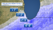
6:14 p.m.: How Much Snow Could Chicago Area See Thursday?
As a winter storm approaches the Chicago area, snowfall projections are being dialed in as the track of that system begins to take shape.
The NBC 5 Storm Team uses two different models to project the amount of snow that will fall during the storm, with the High-Resolution Rapid Refresh model (HRRR) and the High-Resolution North American model (NAM) currently showing similar tracks, but different snowfall amounts, from the system.
As things stand Wednesday afternoon, the NAM is showing a significant snowfall event across the area, with the northern suburbs seeing 6-to-8 inches of snow, the city of Chicago seeing between 7-to-9 inches, and areas in Kankakee County and northwest Indiana potentially seeing a foot or more of snow by Thursday night.
The HRRR model still shows a fairly significant snowfall for the far southern portions of the Chicago area, along with northwest Indiana, but much smaller totals in the city of Chicago and in the northern and western suburbs.
Here are the latest projections.
5:55 p.m.: State, Local Officials Urge Residents to Avoid Unnecessary Trips During Winter Storm
State and local officials are warning residents about potentially treacherous travel conditions on Thursday as a winter storm hits the area, with rain, ice and snow all possible throughout the day.
The Illinois Department of Transportation says that it anticipates that snow-and-ice teams will be deployed overnight Wednesday and into Thursday, but warned that salt and other anti-ice mitigations will be limited in their efficacy because of the heavy rain that will likely wash it away.
“The safest option is to postpone any unnecessary trips and to stay home,” IDOT Secretary Omer Osman said in a statement. “If you must travel, prepare for very slow and potentially hazardous conditions.”
Thunderstorms and rain are expected area-wide on Wednesday, and as temperatures rapidly cool, a wintry mix could fall in northern portions of the state.
As Thursday dawns, the change-over to snow will continue, and after a brief break, heavy snow, along with gusty winds, are expected in the afternoon, potentially causing huge travel concerns during the evening commute.
The rapid snowfall will make it difficult for plows to keep roads passable, and motorists are being advised to give those plows, and emergency vehicles, plenty of room on the roadways.
5 p.m. Chicago's OEMC warns of 'severe winter weather'
Chicago officials urged resident to "take the necessary steps to be prepared for possible lakeshore flooding and dangerous conditions near the lakefront due to large battering waves, heavy rain, high winds, and snow accumulation for the Chicago area." With numerous weather alerts set to take effect across the area, officials warned that travel will likely be impacted for the Thursday morning and evening commutes.
"Plan on slippery road conditions becoming treacherous with low visibility due to falling and blowing snow, especially along lake Michigan," the Office of Emergency Management and Communications wrote.
The department released the following tips for those who must travel:
- Allow extra time to reach your destination.
- Leave plenty of space between vehicles.
- Have a full tank of gas and let friends and relatives know where you are going.
- Make sure you have an emergency kit in your vehicle.
- Yield to emergency vehicles as well as Streets and Sanitation salt spreaders and plows.
- With the potential for flooding, do not drive through high water.
- The heavy wet nature of the snow could also put strain on tree limbs and power lines which may result in some power outages.
- Shoveling snow can be a health risk as well. Remember to stay hydrated, take frequent breaks, and only move small amounts with each shovel pass.
4:50 p.m.: Latest Snow Total Projections
As a winter storm approaches the Chicago area, snowfall projections are being dialed in as the track of that system begins to take shape.
The NBC 5 Storm Team uses two different models to project the amount of snow that will fall during the storm, with the High-Resolution Rapid Refresh model (HRRR) and the High-Resolution North American model (NAM) currently showing similar tracks, but different snowfall amounts, from the system.
As things stand Wednesday afternoon, the NAM is showing a significant snowfall event across the area, with the northern suburbs seeing 6-to-8 inches of snow, the city of Chicago seeing between 7-to-9 inches, and areas in Kankakee County and northwest Indiana potentially seeing a foot or more of snow by Thursday night.
The HRRR model still shows a fairly significant snowfall for the far southern portions of the Chicago area, along with northwest Indiana, but much smaller totals in the city of Chicago and in the northern and western suburbs.
Here is what is being predicted so far.
4 p.m.: Several schools announce closures, switches to e-learning ahead of winter storm
By Wednesday afternoon, nearly two dozen schools and school districts had announced plans to switch to e-learning or close Thursday.
Among those closed were District 13 schools, Dujardin School, Erickson Elementary School and Westfield Middle School in Bloomingdale, along with Taft School District 90 in Lockport.
A number of districts like District 104 in Summit, District 2 in Bensenville, District 45 in Villa Park, District 53 in Oak Brook and District 180 in Burr Ridge had announced plans for remote learning.
4 p.m.: Track and rain and snow with Live Doppler 5 Radar
3:50 p.m. IDOT Warns of 'Hazardous Travel' Across Illinois During Winter Storm
Illinois transportation officials are warning drivers about hazardous conditions expected on roadways across the state as a winter system makes its way through Wednesday night and into Thursday.
The Illinois Department of Transportation said a "major storm" is expected to bring heavy rains, flooding, double-digit snowfalls, ice and high winds, all of which will "create slick conditions, impacting travel across much of the state."
“The Illinois Department of Transportation’s snow-and-ice teams will be prepared and out in force, but the public needs to be ready for conditions to change quickly and worsen if they are out on the roads,” Illinois Transportation Secretary Omer Osman said in a statement. “As always during periods of extreme weather, the safest option is to postpone any unnecessary trips and stay home. If you must travel, prepare for very slow and potentially hazardous conditions. And please slow down around our plows and other emergency vehicles, giving them plenty of room to do their jobs.”
With some locations potentially seeing up to 10 inches of snowfall paired with high winds, the conditions "will make driving difficult, especially for high-profile vehicles on east-west roads, while causing snow to blow and drift."
IDOT's Getting Around Illinois website offers a look at current winter conditions across the state.
Using a map, the site tracks which roadways are clear and which are partly, mostly or completely covered with ice or snow. It also highlights so-called "trouble spots," where things like blowing snow have been reported or bridges and roadways prone to icing.
For those who must travel, IDOT recommends:
- Turn around, don’t drown! Do not attempt to drive through flooded roads. Do not drive around barricades. Delay travel until conditions improve.
- Drastically reduce speeds and take it slow, especially when approaching intersections, ramps, bridges and shaded areas that are prone to icing.
- Make sure your gas tank is full.
- Keep a cell phone, warm clothes, blankets, food, water, a first-aid kit, washer fluid and an ice scraper in your vehicle. Dial *999 in the Chicago area for assistance in case of emergency.
- Check the forecast and make sure someone is aware of your route and schedule.
- Reminder: Using handheld phones while driving is illegal in Illinois, unless it is an emergency.
- If you are involved in a crash or break down, remain inside your vehicle, which is your safest form of shelter. Exiting your vehicle into live traffic can have fatal consequences.
- Always wear a seat belt, whether you’re sitting in the front seat or back seat. It’s the law. Never get behind the wheel impaired.
- Visit www.gettingaroundillinois.com for regular updates on road conditions statewide. You also can follow IDOT on Facebook and Twitter.
3:45 p.m.: A look at the weather alerts issued across the Chicago area and when they take effect
With some locations under a winter storm warning and others under an advisory, what exactly you will see as a winter storm moves across parts of the area will depend largely on where you live.
Here's a full breakdown of which alerts will be in place and when.
Here's a look at the latest threats and timing:
