
With some locations under a winter storm warning and others under an advisory, what exactly you will see as a winter storm moves across parts of the area will depend largely on where you live.
A powerful storm is on the horizon for many, but there's still plenty of uncertainty surrounding the storm's path and what it will mean for parts of the Chicago area. Still, ice, snow and localized blizzard conditions are all possible.
Here is what we know so far as the system approaches the region.
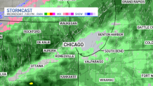
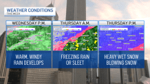
Wednesday Afternoon:
Feeling out of the loop? We'll catch you up on the Chicago news you need to know. Sign up for the weekly Chicago Catch-Up newsletter here.
The storm system will begin to move its way into the Chicago area in the afternoon, bringing rain and high winds, according to forecast models.
In DuPage, La Salle, Kendall, Grundy, Kankakee, Livingston, parts of Cook and parts of Will counties in Illinois, as well as Lake, Porter, Newton and Jasper counties in Indiana, a wind advisory is in effect from 9 a.m. to 6 p.m. Wednesday.
At times, wind gusts could reach 40 to 50 mph, according to the advisory. Weather officials warned small tree limbs could be blown down and power outages are expected.
Local

The anticipated showers are expected to bring 1-to-2 inches of rain to the area, with localized heavier amounts possible, causing potential flooding and slippery road conditions.
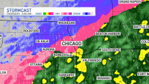
Wednesday Night:
Temperatures will begin to drop Wednesday night, with select locations seeing rain transition to freezing rain and sleet around midnight, according to forecasts.
The transition will likely occur from northwest to southeast due to strong northerly winds, meaning that rain is expected to continue overnight into Thursday morning in many locations.
Overnight Thursday:
Rain will transition to freezing rain across the area, starting in the northern suburbs and slowly making its way down through Chicago and then ultimately into the southern suburbs.
Some areas could see a wintry mix and possibly even a burst of snow heading into the morning hours Thursday.
In several counties, including DeKalb, Kane, DuPage and northern and central Cook, a winter weather advisory takes effect at midnight.
In LaSalle, Kendall, Grundy, Kankakee, southern Cook and Will counties in Illinois, as well as Lake and Porter counties in northwest Indiana, a winter storm warning begins at 3 a.m., warning of snow accumulations between 3 and 8 inches, ice accumulations of up to one tenth of an inch and wind gusts of up to 45 mph, particularly along Lake Michigan. The highest snow totals are expected south of the Illinois and Kankakee rivers, the alert states.
In parts of northern Illinois, snow could potentially begin before sunrise, with the icy mix transitioning to snow in Lake and McHenry counties by the time the sun comes up.
Thursday Morning:
Thursday morning should see snow become more widespread across the area, with the intensity picking up as the morning moves along.
The only places it likely won’t snow before noon are in the far southern suburbs, where freezing rain and mixed precipitation are expected to fall through the late morning to early afternoon.
A winter storm warning begins at 6 a.m. in Newton and Jasper counties in northwest Indiana, warning of snow accumulations between 6 and 10 inches along with wind gusts of up to 40 mph and ice accumulations of up to two tenths of an inch.
Thursday Afternoon and Evening:
By the afternoon hours, snow will be falling across the region, with winds picking up and causing limited visibility and hazardous travel conditions in many areas.
In central Cook County, a winter weather advisory will transitioning to a winter storm warning at 2 p.m., remaining in effect through 9 p.m.
For all counties under a winter storm warning, snowfall rates higher than one inch per hour are expected at times through Thursday afternoon.
"The high snowfall rates combined with the strong winds will result in very low visibility and may cause sporadic power outages from strain on tree limbs and power lines," the warning states.
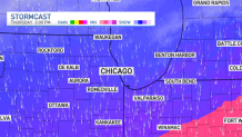
It is not known at this time where exactly the heaviest snowfall amounts will occur as any shift in the storms path could change totals dramatically, but widespread travel issues are expected, with snow tapering off in the evening hours.
In DeKalb and Kane counties the winter weather advisory continues through 6 p.m. Thursday, while in DuPage and northern Cook it stays in effect until 9 p.m.
Overall Look
Overall, the Chicago area can expect a mixed bag of weather. Wednesday's warmth and rain showers will give a taste of spring to the region before the freezing rain, sleet and snow move in Thursday.
By Friday, snowfall totals are not yet confirmed, though meteorologists expect smaller accumulations of 1 to 3 inches in the northern Chicago suburbs, 3 to 6 inches near and to the west of the city, and around 4 to 8 inches in southern counties and northwest Indiana.
The snow, mixed with the threat of ice and wind will likely lead to hazardous conditions across the area.
