
Update at 10:30 a.m.: All morning severe thunderstorm warnings for Chicago area counties in Illinois have expired. However, a second round of strong to severe afternoon storms could move in. Our latest forecast and story can be found here. Our original story continues below.
As hot, humid and even hazy conditions continue for another day in the Chicago area, severe thunderstorm warnings have also begun to take hold Wednesday morning.
According to a 7:49 a.m. tweet from the National Weather Service, a severe thunderstorm warning was in effect for Ogle and Winnebago counties, as "line of thunderstorms" moved towards Northern Illinois at 45 miles per hour.
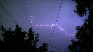
"This line is producing locally heavy rainfall and frequent lightning with the potential for strong wind gusts up to 70 mph and damaging hail possible," the tweet said.
Just after 8 a.m., that severe thunderstorm warning was extended to McHenry County.
At 8:43 a.m., severe thunderstorm warning was also issued for DuPage, Lake, Kane and parts of Cook County in Illinois, and Kenosha county in Wisconsin.
Local


"This storm has had a history of 60 to 70 mile per hour wind gusts and tree damage," an alert from the NWS said. "Expect considerable tree damage," the alert said, adding that counties under the warning could also expect "penny-sized hail."
As of 9:50 a.m., multiple ComEd power outages reported in McHenry county had left at least 1,500 people without power.
Feeling out of the loop? We'll catch you up on the Chicago news you need to know. Sign up for the weekly Chicago Catch-Up newsletter here.
RADAR: Track live weather as severe thunderstorm warnings issued for Chicago area
According to the NBC 5 Storm Team, Wednesday morning's line of storms is expected to continue through at least 9:45 a.m. However, another round is expected in the afternoon, meteorologist Alicia Roman added.
As the mercury continues to rise, here's a look at what your forecast looks like for Wednesday.
Chance of strong to severe storms
Wednesday morning, a fast moving line of storms intensified as it moved towards Northeastern Illinois, bringing severe thunderstorm warnings to Lake, Kane, McHenry and Cook counties in Illinois and Kenosha counties in Wisconsin.
According to the NWS, wind gusts of up to 70 mph and penny-sized hail were expected with that cell, which is expected to move out 9:45 a.m. And while forecast models continue to shift, another round in the afternoon is expected, the NBC 5 Strom Team advised.
Any storms that do develop, Roman said, could be strong to severe, with "all weather hazards at play," including hail, heavy downpours and damaging winds.
According to the Storm Prediction Center, Parts of northeastern Illinois, including McHenry, Lake, Kane, DuPage, Cook, Will and Kankakee counties, are at a “slight risk,” of severe weather, which ranks at level two of five.
Some parts of Northern Indiana however could see an "enhanced" risk of severe weather, the Storm Prediction Center said.
What Chicago's Air Quality?
While there is no air quality alert in place, as of 5:30 a.m., Wednesday, Chicago's air quality remains in the "unhealthy for sensitive groups" category.
Heat Advisory in place for some Chicago area counties
According to an alert from the NWS, Grundy, LaSalle, Kankakee and Will Counties in Illinois, along with Newton and Jasper Counties in Indiana are all under a Heat Advisory until 9 p.m. Wednesday.
In those areas, peak heat index values of 100 to 105 can be expected, the alert advised.
"Hot temperatures and high humidity may cause heat illness to occur," the alert said. "Drink plenty of fluids, study in an air-conditioned room, stay out of the sun. Young children and pets should never be left unattended in vehicles under any circumstances."
According to the NBC 5 Storm Team, temperatures elsewhere in the Chicago area are expected to reach well into the 90s, remaining only slightly cooler near the lake, and dewpoints are expected to rise, making for "very muggy conditions" into the afternoon, Roman said.
For example, O'Hare International Airport is expected to hit a high of 93 degrees. However, high dewpoint temperatures are likely to make that temperature feel like 102, the NBC 5 Strom Team said.
"Definitely more humid today than the last few days -- and you will notice it," Roman warned.
Heat, humidity continues through Thursday and Friday
Forecast models show the heat and humidity is expected to continue through the end of the week, with highs again in the 90s, and heat indices reaching over 100 degrees.
By Saturday and into next week however, temperatures are expected to lower back down into the 80s, forecast models show.
