
Update: More than 3,000 were without power Wednesday morning, and a flash flood advisory was issued for some parts Wednesday morning. The latest information can be found here.
The weather in the Chicago area this week may have started off feeling like summer with heat, humidity and highs in the mid-to-upper 90s. But you're going to want to get your sweaters, scarves and boots ready -- because the week is expected to end feeling like fall.
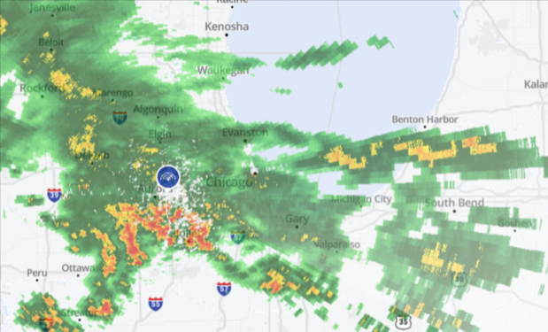
Before that cold front moves in however, showers and storms are expected to continue through Wednesday morning, the NBC 5 Storm Team said.
Around 4:30 a.m., a severe thunderstorm warning was issued for DuPage County, accompanied by winds of up to 60 miles per hour, heavy rain and frequent lightning, the National Weather Service said. And though the warning expired at 5 a.m., strong storms moving through Central and Southern Cook, Lake, Kankakee and Will Counties in Illinois bringing gusty winds and heavy downpours could snarl some Wednesday morning commutes.
Additionally, some "small pea sized hail" is possible, the NWS said.
As of 6:30 a.m., ComEd's outage map reported 3,763 customers were were without power Wednesday morning as the storms continued to pass through. Of those, 2,904 customers were in Cook County and more than 400 were in Will County.
Local

By 6:45 a.m., those numbers had dropped slightly, the map showed.
Just after 6 a.m., the NWS issued a flood advisory and a flash flood warning for parts of Cook County, Will and Kankakee counties, where "between 2 and 4 inches of rain" has already fallen.
Feeling out of the loop? We'll catch you up on the Chicago news you need to know. Sign up for the weekly Chicago Catch-Up newsletter here.
At 7:15 a.m., the FAA said it had "paused" flights to O'Hare due to the storms. An alert on the FAA website indicated that both O'Hare and Midway Airports were under ground stops.
According to NBC 5 Meteorologist Alicia Roman, the storms are expected to gradually come to an end between 7 and 8 a.m., as the cluster of storms continues to push from west to east.
However, some isolated showers and storms could develop in some parts again around 5 p.m. and into the overnight hours, Roman said.
MORE: Could Chicago's winter be snowier, colder than usual? Here's what Farmer's Almanac says
Temperatures Wednesday are expected to remain balmy and humid, with highs in the mid-80s and dewpoints in the 70s, Roman said. Overnight Wednesday is when the Chicago area will begin to get a taste of fall, with high temperatures in the 50s and 60s.
Thursday, temperatures are expected to be below-average, with highs in the upper 60s and low 70s, Roman said.
"Definitely feeling like fall for your Thursday," Roman said.
Temperatures are expected to remain in the 70s for the rest of the week, the NWS said.
