
Much of the Chicago area, particularly southern and western suburbs along with portions of northwest Indiana, are now under a "Moderate" risk for severe weather threats, meaning widespread severe storms are likely. The moderate threat level is the fourth of a five-scale system from the Storm Prediction Center. The previous "Enhanced" threat level is third on the five-scale system. Live radar can be found here. Our original story continues below.
A ground delay has been reported at Chicago's O'Hare International Airport for thunderstorms and flight cancellations continue to climb as severe weather moves through the area.
With potentially dangerous weather in the form of thunderstorms, damaging winds, and the risk of hail and tornadoes threatening the entire Chicago area Friday, cancellations have exceeded 250 at O'Hare and Midway airports combined, the Chicago Department of Aviation's Fly Chicago website shows.
According to the site's flight status tracker, as of 6:20 p.m., O'Hare International Airport showed 196 cancellations and Midway showed 128. According to city officials, the flight disruptions come at one of the busiest travel times of the year: Spring Break and Holy Week.
Feeling out of the loop? We'll catch you up on the Chicago news you need to know. Sign up for the weekly Chicago Catch-Up newsletter here.
"Parking lots at ORD are filling up quickly due to Spring Break travel," O'Hare said in a Tweet Friday morning, accompanied by a photo of a stormy and cloudy sky."
Between Friday March 31 and April 10, more than 2.56 million passengers are expected to travel through both airports
Local

"Compared to the same Spring Break travel period last year, O’Hare is expected to see a passenger increase of 6.7%, and current projections from airlines show that Thursday, April 6 will be the busiest day of travel," the city of Chicago said in a press release.
"At Midway, airlines report a projected increase of 19.1% compared to Spring Break 2022, and the busiest day is expected to be Friday, March 31," the release goes on to say.
MORE: Severe Weather Timeline: What To Expect and When With Storms, Damaging Winds in Forecast
Hour-by-Hour Forecast
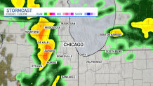
Between 3 p.m. and 10 p.m. is when the area will see its greatest risk for intense and potentially severe weather, with "two rounds possible" in that time frame, the National Weather Service tweeted.
While rain and storms are expected to break in the 11 a.m. hour, they'll begin to pick back up again between 2 and 3 p.m. And according to the NBC 5 Storm Team, these storms have the potential to be severe.
The Storm Prediction Center shows the entire Chicago area including suburbs along the lake and to the north, west and south is under an "enhanced" risk of severe weather beginning around 3 p.m.
That risk level ranks at a three on a scale of five, the NBC 5 Storm Team says.
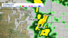
Between 4 and 5 p.m., numerous storms across the region are possible, the NBC 5 Storm Team says, with frequent lightning, torrential downpours, a limited hail risk and an area-wide threat of rain-wrapped tornadoes. And in addition to the gusty winds expected outside of the storm, powerful gusts during a thunderstorm could exceed 70 miles per hour.

Another storm with the same threats moves in between 7 p.m. and 8 p.m. from west to east and will blow through the area quickly, traveling at speeds of 60-to-70 miles per hour.
By 9 p.m., it's expected to hit northwest Indiana, and northwest Michigan swinging as far east as South Bend, and as far north as Benton Harbor.
Wind Advisory
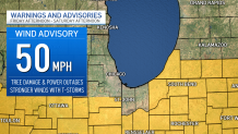
According to the NBC 5 Storm Team, a wind advisory with gusty winds up to 50 miles per hour will take effect at 3 p.m. Friday for counties mainly near and to the south of I-80. The advisory will last until 1 p.m. Saturday, the National Weather Service says, with tree damage, power outages all possible.
Even stronger winds could be accompanied by the storms moving through the area, the NBC 5 Storm Team says.
MORE: ‘Prepare For The Worst': What To Do If You're Driving When Severe Weather, Tornadoes Hit
Another storm with the same threats moving in between 7 and 8 p.m. from west to east will blow through the area quickly, traveling at speeds of 60-to-70 miles per hour. By 9 p.m., it's expected to hit Northwest Indiana.
According to ComEd, in the event of power outages, power will be restored to critical infrastructure such as hospitals, police and fire stations and nursing homes first, followed by repairs that will restore power to the greatest amount of customers.
“The significant winds that will accompany this storm could be impactful to our customers and communities,” said Dave Perez, senior vice-president of Distribution Operations, ComEd. “We know that any outage is an inconvenience. Our crews will be working around the clock to restore customers that experience outages quickly and safely.”
Weekend Weather
Overnight hours are expected to be dry, and temperatures Saturday are expected to drop dramatically, going back into the mid 40s. Additionally, the morning hours could see a chance for some mixed precipitation.
By Saturday afternoon, winds are going to pick up considerably, with some gusts exceeding 30-to-40 miles per hour, according to forecast models.
Sunday is expected to be dry, and temperatures will be back up into the upper-50s and low-60s, forecast models show.
