
NOTE: Severe weather has since moved out of the Chicago area. Find the latest coverage on storm damage here.
Tornado watches and severe thunderstorm warnings were issued in the Chicago area Friday evening as two rounds of severe storms moved across the region, bringing winds up to 90 miles per hour and causing a roof collapse at a music venue in Belvidere.
While storms continued to affect the area well into the evening, the National Weather Service confirmed that the severe weather threat for the Chicago area has concluded for the evening.
The NWS had tweeted at 8:09 p.m. that severe storms capable of destructive winds exceeding 75 miles per hour and tornadoes continued to race across northern Illinois.
Feeling out of the loop? We'll catch you up on the Chicago news you need to know. Sign up for the weekly Chicago Catch-Up newsletter here.
Additionally, a tornado watch is in effect for numerous Chicago-area counties until 10 p.m., according to the National Weather Service. Included are the following counties: Cook, DuPage, Kankakee, Lake and Will counties in Illinois, as well as Jasper, Lake, Newton and Porter counties in Indiana. Separately, a tornado watch was issued for LaPorte County, Indiana, until 2 a.m.
Multiple tornado warnings and watches were issued for other portions of the Chicago area, but had expired at around 8 p.m.
Local

The storms will likely remain in the region for hours before exiting around 11 p.m. or so. With damaging winds and tornadoes expected, people are advised to be especially cautious and make the recommended preparations.
Earlier, an initial round of fierce storms swept through, bringing intense winds and large hail to numerous communities. Just before 6 p.m., that storm system continued to push through the region, moving northeast - with a small hail risk and wind gusts of up to 45 miles per hour, according to the National Weather Service.
REAL-TIME STORM COVERAGE: From flight cancellations to details on power outages, find the latest storm updates here.
Much of the area, particularly southern and western suburbs along with portions of northwest Indiana, are now under a moderate risk for severe weather threats, meaning widespread severe storms are likely. The moderate threat level is the fourth of five-scale system from the Storm Prediction Center.
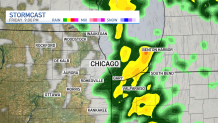
Track the systems live with our interactive radar here
The change in threat level was largely "due to significant wind gusts" expected across the region.
In far western Illinois, a "high" threat level was also issued. There "several to numerous tornadoes are expected to form," according the Storm Prediction Center, though forecasters warn those storms could continue to move east.
MORE: Flight Cancellations Pile Up at O'Hare, Midway Airports as Storms Hit
By 9 p.m., it's expected to hit northwest Indiana, and northwest Michigan swinging as far east as South Bend, and as far north as Benton Harbor.
Wind Advisory
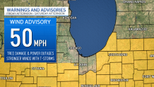
According to the NBC 5 Storm Team, a wind advisory with gusty winds up to 50 miles per hour took effect at 3 p.m. Friday for counties mainly near and to the south of I-80. The advisory will last until 1 p.m. Saturday, the National Weather Service says, with tree damage, power outages all possible.
Even stronger winds could be accompanied by the storms moving through the area, the NBC 5 Storm Team says.
MORE: ‘Prepare For The Worst': What To Do If You're Driving When Severe Weather, Tornadoes Hit
According to ComEd, in the event of power outages, power will be restored to critical infrastructure such as hospitals, police and fire stations and nursing homes first, followed by repairs that will restore power to the greatest amount of customers.
“The significant winds that will accompany this storm could be impactful to our customers and communities,” said Dave Perez, senior vice-president of Distribution Operations, ComEd. “We know that any outage is an inconvenience. Our crews will be working around the clock to restore customers that experience outages quickly and safely.”
Weekend Weather
Overnight hours are expected to be dry, and temperatures Saturday are expected to drop dramatically, going back into the mid 40s. Additionally, the morning hours could see a chance for some mixed precipitation.
By Saturday afternoon, winds are going to pick up considerably, with some gusts exceeding 30-to-40 miles per hour, according to forecast models.
Sunday is expected to be dry, and temperatures will be back up into the upper-50s and low-60s, forecast models show.
