
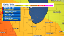
Update at March 31, 12:35 p.m: Much of the Chicago area, particularly southern and western suburbs along with portions of northwest Indiana, are now under a "Moderate" risk for severe weather threats, meaning widespread severe storms are likely. The moderate threat level is the fourth of a five-scale system from the Storm Prediction Center. The previous "Enhanced" threat level is third on the five-scale system. Live radar can be found here. Our original story continues below.
New to the Chicago area? Welcome to spring -- also known to some as severe weather season.
The first of several soaking showers and storms accompanied by bits of lightning and rumbles of thunder rolled across the region overnight, and some will continue to linger through the Friday morning hours, the NBC 5 Storm Team says.
MORE: Severe Weather Timeline: What To Expect and When With Storms, Damaging Winds in Forecast
Feeling out of the loop? We'll catch you up on the Chicago news you need to know. Sign up for the weekly Chicago Catch-Up newsletter here.
According to forecast models, this round is quickly headed east. But another stronger batch of storms is set to arrive this afternoon and evening, the NBC 5 Storm Team says, bringing with it everything from potentially severe thunderstorms and damaging winds, to the possibility of hail and "rain-wrapped" tornadoes.
Here's a breakdown of where the weather forecast stands now, and what to expect as severe weather moves in.
Morning Spotty Showers, Warm Temperatures
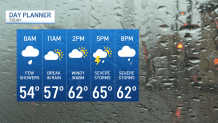
Heavy overnight downpours will continue to work its way out of the area and move towards Northwest Indiana and Northwest Michigan, the NBC 5 Storm Team reports. Some spotty showers are expected to remain in the morning hours to the north and west, across McHenry, Lake and Cook counties.
Local


While those lingering morning showers and storms are non-severe, unseasonably warm temperatures already above 50 degrees and gusty winds clocking in around 30 miles per hour at O'Hare International Airport will set the stage for more activity to come in the late afternoon, following a lull in storm activity.
Numerous Storms Possible; Tornado Risk
According to the NBC 5 Storm Team, rain and storms will break between 7 a.m. and 8 a.m., with a lull continuing through lunchtime. By noon, some sun is expected to shine, and temperatures are expected to hit 60 across the area.
But don't let that fool you.
Between 2 p.m. and 3 p.m., a second wave of storms and rain is set to arrive. And according to the NBC 5 Storm Team, these storms have the potential to be severe.
The Storm Prediction Center shows the entire Chicago area including suburbs along the lake and to the north, west and south is under an "enhanced" risk of severe weather this afternoon and into the evening. That risk level ranks at a three on a scale of five, the NBC 5 Storm Team says.
Around 4 p.m., numerous storms across the region are possible, the NBC 5 Storm Team says, with frequent lightning, torrential downpours, a limited hail risk and an area-wide threat of rain-wrapped tornadoes. In addition gusty winds expected outside of the storm, wind gusts during a thunderstorm could exceed 70 miles per hour.
MORE: ‘Prepare For The Worst': What To Do If You're Driving When Severe Weather, Tornadoes Hit
Another storm with the same threats moving in between 7 and 8 p.m. from west to east will blow through the area quickly, traveling at speeds of 60-to-70 miles per hour.
By 9 p.m., it's expected to hit Northwest Indiana and Northwest Michigan
Wind Advisory
According to the NBC 5 Storm Team, a wind advisory with gusty winds up to 50 miles per hour will take effect at 3 p.m. Friday for counties mainly near and to the south of I-80. The advisory will last until 1 p.m. Saturday, the National Weather Service says, with tree damage, power outages all possible.
Even stronger winds could be accompanied by the storms moving through the area, the NBC 5 Storm Team says.
According to ComEd, in the event of power outages, power will be restored to critical infrastructure such as hospitals, police and fire stations and nursing homes first, followed by repairs that will restore power to the greatest amount of customers.
“The significant winds that will accompany this storm could be impactful to our customers and communities,” said Dave Perez, senior vice-president of Distribution Operations, ComEd. “We know that any outage is an inconvenience. Our crews will be working around the clock to restore customers that experience outages quickly and safely.”
Weekend Weather
Overnight hours are expected to be dry, and temperatures Saturday are expected to drop dramatically, going back into the mid 40s. Additionally, the morning hours could see a chance for some mixed precipitation.
By Saturday afternoon, winds are going to pick up considerably, with some gusts exceeding 30-to-40 miles per hour, according to forecast models.
Sunday is expected to be dry, and temperatures will be back up into the upper-50s and low-60s, forecast models show.
