
Multiple rounds of severe storms are expected to hit the Chicago area Thursday, bringing threats of hail, damaging winds, heavy downpours and possibly even tornadoes.
The first round has already made its way through, but forecast models show two more rounds of strong to severe thunderstorms could still move through the area.
Almost all of the Chicago area, with the exception of Lake and McHenry counties in Illinois, are under a severe thunderstorm watch.
So what can you expected and when?
Here's a timeline:
Latest severe weather alerts
- A severe thunderstorm watch that was issued in the late-morning hours for nearly the entire Chicago area remains in effect throughout the afternoon and until 5 p.m. Counties included in the watch were DeKalb, LaSalle, Cook, DuPage, Grundy, Kane, Kendall and Will counties in Illinois and Lake and Porter counties in northwest Indiana. The watch was canceled just after 3 p.m. for Kankakee County in Illinois and Jasper and Newton counties in Indiana.
- A severe thunderstorm warning was also issued for southwestern LaSalle County until 1:45 p.m.
- Severe thunderstorm warning issued for all of LaSalle and Grundy counties until 2:30 p.m.
- A severe thunderstorm warning was issued for Kankakee until 2:30 p.m.
- Northwestern LaSalle under a severe thunderstorm warning until 3 p.m.
Thursday afternoon brings risk for 'most damaging' storms
Local

According to the National Weather Service, the severe threat largely centers on the afternoon hours.
Feeling out of the loop? We'll catch you up on the Chicago news you need to know. Sign up for the weekly Chicago Catch-Up newsletter here.
According to NWS, this round has the potential to be "the most damaging," as a line of storms "races in from the Plains."
The storms are expected to move in between 12 p.m. and 4 p.m. from west to east. The greatest threats will be south of Interstate 88.
"These storms are moving very quickly to the east at 50 to 60 mph," the NWS tweeted. "Seek shelter indoor and away from windows if a warning is issued for your area!"
"Destructive" wind gusts of up to 8- mph, damaging hail of up to 2 inches in diameter and a tornado or two cannot be ruled out. The NBC 5 Storm Team noted a derecho is also possible, meaning a widespread and lasting wind storm could be associated with these rapidly moving storms.
"An ongoing line of severe storms is now moving into western IL and will continue to push east toward the area into early afternoon! Have multiple ways to receive warning info today!" the NWS warned. (Download the NBC Chicago app to get real-time alerts and track the radar here)
By 3 p.m., however, the NWS said the threat was "gradually waning," though some risk remained for the next couple hours.
Thursday evening and overnight could see a third round
A third round of storms is expected to occur during parts of the Thursday evening commute, between 5 and 9 p.m., forecast models show. According to the NWS, the third round will pose a greater threat in far northern counties, near the Illinois-Wisconsin state line, stretching as far east as Waukegan, to as far west as near Mount Carroll.
That round of storms has the potential to bring strong and damaging hail and winds, and the potential for a tornado, the NWS says.
According to the NBC 5 Storm Team, the risk of Thursday's storms becoming severe depends on location. In much of the Chicago area, the risk remains "slight" on the Storm Prediction Center's six-level scale. Farther south, the risk is greater, in the "enhanced" category.
Overnight Friday, storms and showers are expected to continue.
What else to know
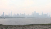
Another threat across the area Thursday continues to be air quality.
Despite heavy overnight rain and showers, smoke and haze from Canadian wildfires continues to the impact air quality in the Midwest and beyond, with the Chicago area's air quality registering at "unhealthy" to "very unhealthy" levels for the third day in a row.
Temperatures highs Thursday are expected to be in the upper 70s to mid 80s, with building humidity. Additionally, an Air Quality Alert for northwest Indiana and northeast Illinois remains in effect until midnight.
This story will be updated.
