
Dangerous travel conditions were reported Monday afternoon as a heavy band of snow moved across parts of the Chicago area, bringing "near whiteout conditions."
At 12:40 p.m., the National Weather Service reported "VERY heavy lake effect snow" across parts of parts of Cook County.
"Near whiteout conditions are occurring in the heart of this band w/ snowfall rates of 2"+ per hour possible resulting in DANGEROUS travel conditions," the NWS tweeted. "Additional snow moves in the PM."
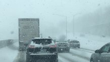
The Illinois Department of Transportation also reported just before noon that several roadways were already covered in snow and ice "with high winds blowing snow around."
"Both are greatly impacting visibility," IDOT tweeted.
Illinois State Police reported all northbound lanes of Interstate 55 were shut down at Illinois Route 30 Monday afternoon for a traffic crash, though the cause of the accident remains unclear. It was not immediately known if weather played a role but police urged motorists to avoid the area and slow down.
Just after 1 p.m., both northbound and southbound lanes were closed. Details on if any injuries were reported were not yet released. ISP said northbound lanes were expected to remain closed for several hours.


The Illinois Department of Transportation and Illinois State Police urged drivers Monday to "strongly consider postponing any unnecessary travel," warning of extremely slick conditions and poor visibility.
“As always, our team at IDOT will be out on the roads around the clock, but if you can stay indoors, please do, especially during the overnight hours,” Acting Illinois Transportation Secretary Omer Osman said in a statement. “Conditions at times could be treacherous, with the cold and wind reducing the effectiveness of the materials we use to treat snow and ice. Expect extremely long travel times and always prepare your vehicle in the event you are stranded.”
Chicago Mayor Lori Lightfoot and the city's Office of Emergency Management and Communications, along with other city leaders, are expected to give an update on the "extreme weather conditions" Monday afternoon. (Watch live here at 2 p.m.)
Much of the Chicago area is under a winter storm warning throughout Monday and continuing through Tuesday morning, with more than a foot possible in a matter of hours.
The city could see some of the highest totals with heaviest amounts expected along the lakefront.
A winter storm warning for Cook County that took effect at 3 a.m. Monday will last through 12 p.m. Tuesday.
The alert warns of up to 13 inches of snow, with some locations seeing potentially even higher totals. Wind chills near 20 degrees below zero are also expected.
Several locations saw nearly 2 inches fall by early Monday, but more snow was expected through the afternoon and evening hours.
Heavy snow and cold temperatures are expected, making for low visibility and dangerous travel conditions in particular. The NWS notes that the worst conditions are expected late Monday afternoon through Tuesday morning, impacting commutes both to and from work.
"If you must travel, keep an extra flashlight, food, and water in your vehicle in case of an emergency," the winter storm warning states.
Illinois officials said blowing and drifting snow throughout the state are likely "due to the amounts and fluffiness of the snow combined with high winds."
“If you must travel, we ask that you allow additional time to reach your destination and ensure your vehicle is in a safe operating condition,” ISP Director Brandon Kelly said in a statement. “Please obey all traffic laws and posted speed limits. Remember, speed limits are set for clear conditions. Only drive the speed limit if it is safe to do so. And please watch out for emergency responders and highway maintainers who are doing their best to keep the roadways safe.”
Overnight lows will range from -2 well inland to 10 above zero in northwest Indiana, but wind gusts up to 20 to 25 mph will make the wind chill readings between -5 to -15 degrees.
Tuesday morning will still see some light snow across the area. But heavier lake effect snow will continue throughout the afternoon, primarily in Cook County, before tapering to a few light snow showers in the evening.
When bad weather hits, it's always best to stay off the roads. If you don't have a choice, here is some advice for traveling in difficult winter conditions.
