
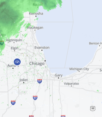
Depending on where you live in the Chicago area, there could be a dramatic difference in the snow totals you are expected to see as yet another winter storm hits.
The latest system will dump the heaviest totals in Chicago and suburbs along Lake Michigan, but several other locations could still see higher amounts.
A winter storm warning took effect for several Chicago-area counties early Monday, warning of accumulations of 8 to 13 inches in parts, possibly more.
Here's a breakdown by county:
Cook County
Cook County is expected to see the most accumulation in this system. A winter storm warning that began early Monday morning and continues through noon Tuesday warns of up to 13 inches of snow, with some locations seeing potentially even higher totals, particularly those near the lake. Wind chills near 20 degrees below zero are also expected.
Several suburbs saw nearly 2 inches fall by early Monday, but more snow was expected.
Local
Lake County
In Lake County, particularly Waukegan, Buffalo Grove, Mundelein, and Gurnee, a storm warning begins at noon and continues through noon Tuesday. Here 5 to 10 inches of snow is expected, with locations closest to the lake potentially seeing higher amount. Wind chills near 20 degrees below zero are also expected.
Kankakee and Eastern Will counties in Illinois, Lake, Porter, Newton and Jasper counties in NW Indiana
A winter storm warning is in effect for Kankakee and eastern Will counties in Illinois, as well as Lake, Porter, Newton and Jasper counties in northwest Indiana.
The warning, which continues through 9 a.m. CST Tuesday, predicts anywhere from 6 to 10 inches of accumulation, with higher amounts possible closest to the lakefront.
Already by 3 a.m. Monday, Valparaiso in Porter County had seen 10 inches of accumulation, with heavy snow falling from midnight to 3 a.m. at a rate of nearly 3 inches per hour.
In Chesterton, Indiana, as much as 7 inches had fallen by 7 a.m. Monday.
DuPage, Kendall, Grundy, Livingston, Northern and Southern Will Counties
Here a winter storm warning remains in effect until 9 a.m. Tuesday, warning of anywhere from 5 to 9 inches of snow expected.
This includes the cities of Naperville, Wheaton, Downers Grove, Lombard, Carol Stream, Oswego, Yorkville, Plano, Morris, Coal City, Minooka, Pontiac, Dwight, Fairbury, Joliet, Bolingbrook, Plainfield, Mokena, Channahon, Manhattan, and Wilmington.
McHenry and DeKalb Counties
For McHenry and DeKalb Counties - including the cities of Crystal Lake, Algonquin, McHenry, Woodstock, Dixon, DeKalb, and Sycamore - a winter weather advisory takes effect at 3 p.m. Monday and continues through 9 a.m. Tuesday. The advisory warns of anywhere from 2 to 5 inches of snow expected.
Kane and LaSalle Counties
In Kane and LaSalle counties- Including the cities of Aurora, Elgin, Ottawa, Streator, La Salle, Mendota, and Marseilles - a winter weather advisory was in effect early Monday morning through 9 a.m. Tuesday. Here, anywhere from 3 to 6 inches of snow is possible.
In Elgin, nearly 2 inches was already reported by 8 a.m. Monday.
LaPorte County in Indiana
A winter weather advisory took effect early Monday and will continue through 9 a.m. Tuesday in LaPorte County. Anywhere from 4 to 8 inches of snowfall is possible with the heaviest amounts expected to fall Monday evening and into Tuesday morning.
