
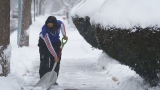
A winter El Niño is likely and it could have dramatic impacts on the season's forecast, even in the Chicago area.
NBC 5 Storm Team Meteorologist Kevin Jeanes said the latest predictions show an 80% chance of a strong El Niño for the coming months and that plays a major role in the seasonal predictions.
"So I want to break this down. Although Chris Farley explained this best, I'm going to try to live up to his name here," Jeanes said this week. "[There's an] 80% chance of a strong El Niño this winter. And an El Niño happens when the wind near the equator over the Pacific Ocean is moving from the west to the east."
Not to be confused with La Niña, which is when winds shifts in the opposite direction, El Niño means "we're looking at, this year, warmer waters in the Pacific," Jeanes said.
"That impacts the jet stream and the pattern that the jet stream takes, meaning where the storms are going to be headed and where the cold air is going to be dropping south from Canada," he added.
Far out projections anticipate "slightly drier than average" conditions for parts of the Midwest in the coming months, but temperatures are expected to be "slightly above average" as well.
In NOAA's recently released seasonal temperature outlook, which offers predictions for Dec. 1, 2023 to Feb. 29, 2024, forecasters are “leaning” toward a warmer-than-normal winter for most of Illinois and Indiana. Additionally, NOAA believes that the typical El Niño pattern of drier-than-normal precipitation levels for the Midwest are expected to hold for 2024.
Local

That level of confidence grows for areas near Lake Michigan, with forecasters saying temperatures will “likely” be above normal for the winter months, including in the city of Chicago.
In terms of precipitation, most of Illinois is expected to have roughly normal snowfall amounts this winter, but nearly all of Indiana, as well as far-eastern Illinois, is projected to have below-average amounts of precipitation during the winter.
Feeling out of the loop? We'll catch you up on the Chicago news you need to know. Sign up for the weekly Chicago Catch-Up newsletter here.
Typically, at O'Hare Airport, average snowfall for the month of December is 8 inches. For January it sits at 11.3 inches and for February, the number is 10.7 inches.
Already, however, the season's first flurries could come well before December, with Chicago potentially seeing the first flakes and flurries of the season on Halloween, the NBC 5 Storm Team noted Friday.
Typically, an El Niño year can mean parts of the northern U.S. and Canada are drier and warmer than usual, but the Gulf Coast and Southeast can see wetter-than-normal conditions, along with an increased risk of flooding.
Last winter provided a surprising amount of rain and warmer-than-normal temperatures in the Chicago area and the latest forecast could mean a repeat.
Typically for Illinois, an El Niño event's impact varies depending on its size, intensity, and duration, Angel said.
"As a result, the impacts can vary from one event to the next. In addition, there may be other factors that influence Illinois weather during these events," Angel said.
In general, some of the impacts could include:
- Summers tend to be slightly cooler and wetter than average
- Falls tend to be wetter and cooler than average
- Winters tend to be warmer and drier
- Springs tend to be drier than average
- Snowfall tends to be below average
- Heating degree days tend to be below average, which means lower heating bills.
Such a development would be in line with how El Niño events typically unfold. During those instances, Illinois and the Chicago area typically see warmer temperatures and below-normal precipitation, especially in the fall and winter months, according to researchers at the University of Illinois.
