


Update at March 31, 12:35 p.m: Much of the Chicago area, particularly southern and western suburbs along with portions of northwest Indiana, are now under a "Moderate" risk for severe weather threats, meaning widespread severe storms are likely. The moderate threat level is the fourth of a five-scale system from the Storm Prediction Center. The previous "Enhanced" threat level is third on the five-scale system. Live radar can be found here. Our original story continues below.
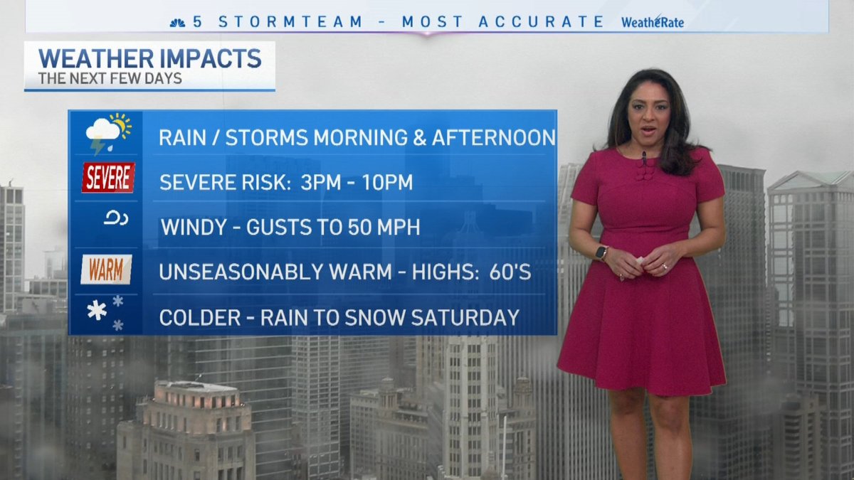
Although Friday morning is expected to mild, dry and warm, severe weather is threatening the entire Chicago area, beginning around 3 p.m.
At that time, the first of at least two rounds of fast moving, heavy rain and thunderstorms -- some strong and potentially severe -- are expected to quickly roll in, bringing with them powerful winds and the risk of both large hail and rain-wrapped tornadoes.
The Storm Prediction Center shows the entire Chicago area, including suburbs along the lake and to the north, west and south is under an "enhanced" risk of severe weather beginning around 3 p.m.
That risk level ranks at a three on a scale of five, the NBC 5 Storm Team says.
Additionally, latest forecast models show the potential severe weather stretching into Northwest Indiana as far east as South Bend, and into Northwest Michigan as far north as Benton Harbor.

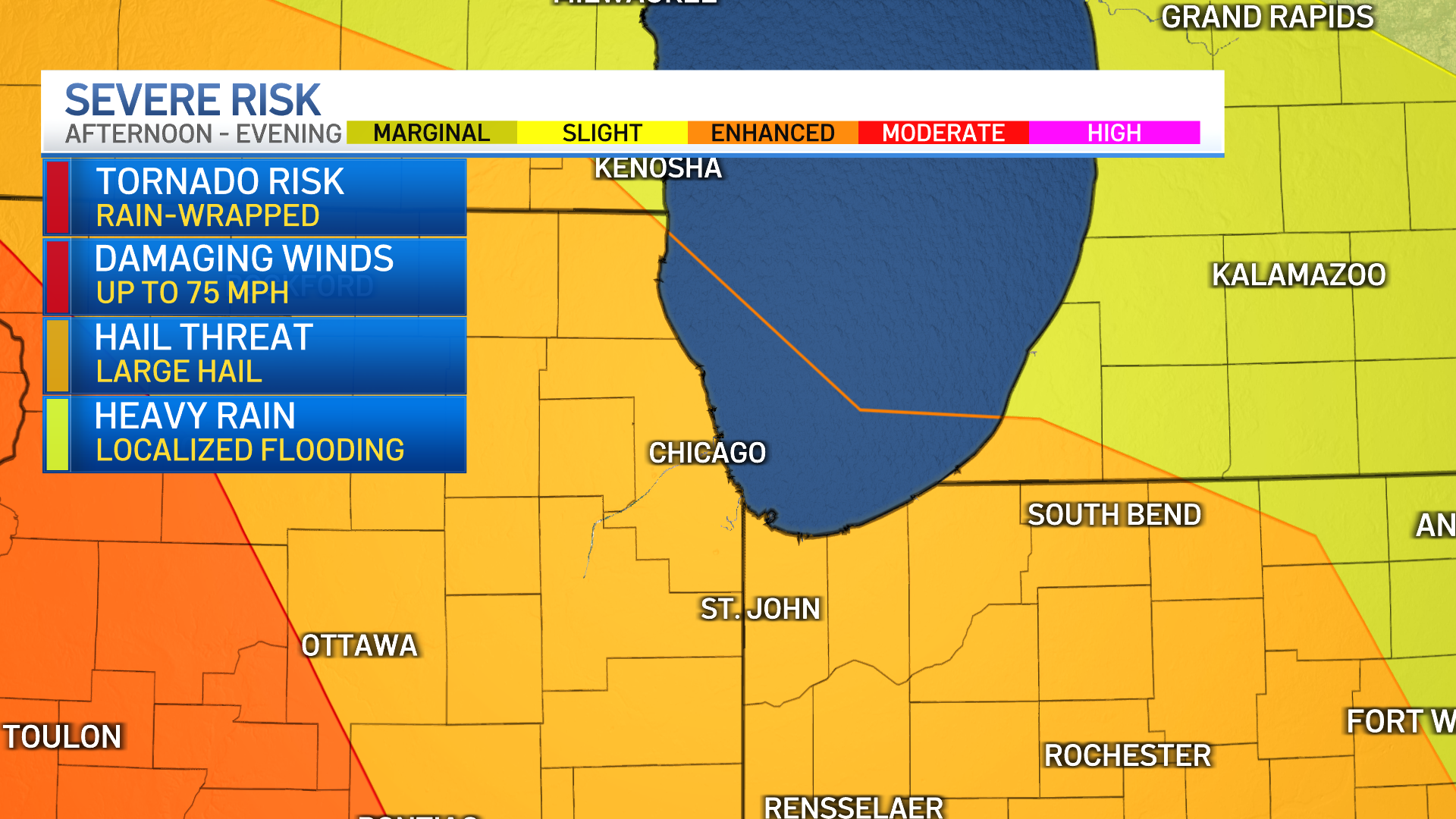
And while the storms are expected to be quick and fast moving, they're predicted to occur throughout the afternoon commute and even into rush hour, with the strongest storms likely to between 3 p.m. and 10 p.m.
Local


Feeling out of the loop? We'll catch you up on the Chicago news you need to know. Sign up for the weekly Chicago Catch-Up newsletter here.
According to the NBC 5 Storm Team, the greatest threats associated with Friday's numerous storms is damaging winds, large hail, heavy rain, localized flooding, and tornadoes. And while gusty winds of up to 40 miles per hour outside of thunderstorms are expected to occur, winds during the storms are signifanctly stronger, at between 60 and 70 miles per hour.
In other words, "prepare for the worst," NBC 5 meteorologist Alicia Roman says. Here are a few tips on what to do when the weather hits, whether you're in your car, outside, or at home.
Make Sure You Have a Way To Receive Warnings
Stay up-to-date on the forecast in your area by signing up for weather alerts through the NBC 5 app. This allows you to receive immediately get notified about watches warnings and advisories from the National Weather Service as they occur.
You can also check the track of the storms through the NBC 5 Storm Team radar on the app.
When Severe Weather Hits: If You're Inside
Before the severe weather hits, determine a safe place in your home to go to. You'll want this to be a strong, interior room, like the center of a basement, the NBC 5 Storm Team says. Keep away from windows.
When Severe Weather Hits: If You're Driving
Before you hit the road today, check the latest severe weather timeline. Will you be driving at that time? If so, prepare ahead of time. Make sure your phone is fully charged, and prepare an emergency driving kit. Tell family and friends ahead of time where you plan to be, the route you're taking and at time you'll be on the road.
If you are in the car or outside during a tornado warning, "the best thing to do is to abandon your car," NBC 5 Meteorologist Alicia Roman says. "Find shelter immediately," or get low-laying in a ditch or a ravine.
Finally, make sure to cover your head.
Be Aware Of Advisories
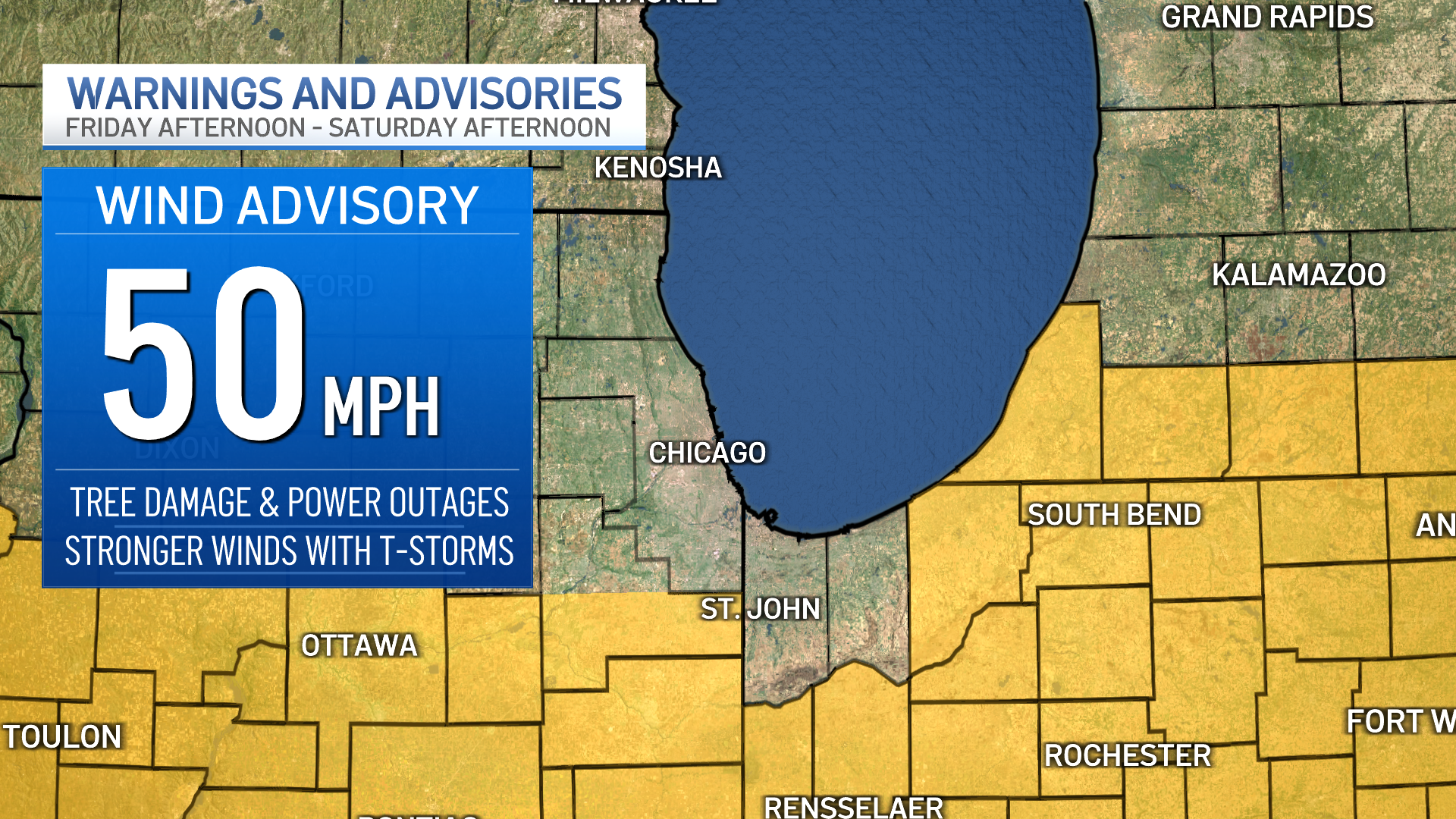
According to the NBC 5 Storm Team, a wind advisory with gusty winds up to 50 miles per hour will take effect at 3 p.m. Friday for counties mainly near and to the south of I-80. The advisory will last until 1 p.m. Saturday, the National Weather Service says, with tree damage, power outages all possible.
Even stronger winds could be accompanied by the storms moving through the area, the NBC 5 Storm Team says.
According to ComEd, in the event of power outages, power will be restored to critical infrastructure such as hospitals, police and fire stations and nursing homes first, followed by repairs that will restore power to the greatest amount of customers.
“The significant winds that will accompany this storm could be impactful to our customers and communities,” said Dave Perez, senior vice-president of Distribution Operations, ComEd. “We know that any outage is an inconvenience. Our crews will be working around the clock to restore customers that experience outages quickly and safely.”
Weekend Weather
Overnight hours are expected to be dry, and temperatures Saturday are expected to drop dramatically, going back into the mid 40s. Additionally, the morning hours could see a chance for some mixed precipitation.
By Saturday afternoon, winds are going to pick up considerably, with some gusts exceeding 30-to-40 miles per hour, according to forecast models.
Sunday is expected to be dry, and temperatures will be back up into the upper-50s and low-60s, forecast models show.

