
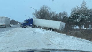
A powerful winter storm bringing dangerously low wind chills, powerful winds, icy roads and snow that barreled through multiple states, including Illinois and Indiana, left travelers scrambling at airports as hundreds of flights were canceled, and motorists braving dangerous, icy roads.
Friday, while a winter storm warning went into effect for the entire Chicago area, a blizzard warning took effect in parts of Northwest Indiana, with white-out and slick driving conditions leading to numerous accidents and hazardous highways.
And while much of the storm had passed by Saturday, wind chills 30 degrees below zero left roads in many places remained iced-over throughout the holiday weekend.
According to the Illinois State Police, troopers responded to crashes, slide offs and stranded motorists Thursday through Sunday morning.
Feeling out of the loop? We'll catch you up on the Chicago news you need to know. Sign up for the weekly Chicago Catch-Up newsletter here.
"We specifically want to tip our caps to the Indiana Department of Transportation who were working around the clock, doing their best to make the roads simply passable in some locations," a press release from the ISP said. "Their battle with the winds and arctic temperatures made their work seem futile we’re sure, but they persevered and didn’t stop plowing."
According to statistics compiled by the department, as a result of the storm, patrols responded to 153 reports of property damage, 28 crashes involving injuries and 83 slide offs that required tows.
"A thank you to all the tow agencies that responded and towed vehicles in elements not seen in years," the release continued. "Enjoy the warm weather that is headed our way this week."
Local

Next Week's Forecast
Colder-than-average temperatures are expected to stick around after the holiday weekend, with another chance of snow arriving on Monday. The quick-moving system won’t cause significant accumulations, and should clear the area by the evening hours, according to forecasts.
By Wednesday things are really going to change rapidly in the area, with temperatures rising above freezing for the remainder of the calendar year.
By Thursday, temperatures will be in the upper-40s or perhaps even the low-50s in some locations, and they’ll remain there through next weekend. Those temps will also be accompanied by a persistent threat of rain over the New Year’s weekend, with the most widespread showers occurring Friday and into Saturday, according to extended forecast models.
For the latest forecasts and information, download the NBC Chicago app.
