
Canadian wildfires will send worsening smoky air across the country and neighboring United States in coming days after recent heavy rains in Quebec missed the places where the fires are most active, officials said Wednesday.
Smoke from the wildfires has lowered curtains of haze on broad swaths of Canada and the United States, pushing into Illinois, Indiana and Ohio, and moving into parts of West Virginia.
Canadian officials say it is the nation’s worst wildfire season ever and they expect air quality to remain a concern through the summer, as long as the fires continue.
Here's what to know and what it could mean for the Chicago area:
Feeling out of the loop? We'll catch you up on the Chicago news you need to know. Sign up for the weekly Chicago Catch-Up newsletter here.
Where are the Canadian wildfires?
Nearly every province in Canada has fires burning.
There are 490 fires burning nationally, with 255 of them considered to be out of control. Quebec’s forest fire prevention agency is reporting 110 active fires.
U.S. & World

How much has burned in the Canadian wildfires?
Canada has already surpassed the record for area burned. A record 30,000 square miles (80,000 square kilometers) of Canada has burned, an area nearly as large as South Carolina, according to the Canadian government.
"This season has been unprecedented,” Environment and Climate Change Canada Meteorologist Steven Flisfeder said.
The Canadian Interagency Forest Fire Centre reported Monday that 76,129 square kilometers (29,393 square miles) of land including forests has burned across Canada since Jan. 1. That exceeds the previous record set in 1989 of 75,596 square kilometers (29,187 square miles), according to the National Forestry Database.
The National Weather Service reports the 10-year average for this time of year is 1,624 fires and roughly 980 square miles burned.
"In an average year, only about one square mile would be burned by June 5, according to Quebec’s fire prevention agency, Société de protection des forêts contre le feu (SOPFEU)," the NWS reports.
What sparked the Canada wildfires?
According to the National Weather Service, some of the fires were ignited by lightning.
Much of the region also remains "abnormally dry" or under a "moderate drought." The fires started early on drier-than-usual ground and accelerated very quickly, exhausting firefighting resources across the country, fire and environmental officials said.
Officials have warned that there are more out of control fires than the SOPFEU can handle with available resources.
In early June, U.S. President Joe Biden said in a statement that hundreds of American firefighters and support personnel have been in Canada since May, and called attention to the fires as a reminder of the impacts of climate change.
The warming planet will produce hotter and longer heat waves, making for bigger, smokier fires, according to Joel Thornton, professor and chair of the department of atmospheric sciences at the University of Washington.
Where has smoke been reported?
Drifting smoke from the ongoing wildfires across Canada is creating curtains of haze and raising air quality concerns throughout the Great Lakes region and in parts of the central and eastern United States.
Earlier this month, massive fires burning stretches of Canadian forests blanketed the northeastern United States and the Great Lakes region, turning the air yellowish gray, and prompting warnings for people to stay inside and keep windows closed.
In Chicago, officials urged young people, older adults and residents with health issues to spend more time indoors.
In the Milwaukee area, Flight for Life Wisconsin was unable to respond to a motorcycle-van crash because the Federal Aviation Administration requires 2 miles (3.2 kilometers) visibility, and the visibility was reduced to three-quarters to 1.5 miles (1.2-2.4 kilometers) because of the hazy skies, Executive Director Leif Erickson said.
Smoke from the wildfires moved into Minnesota late Monday, and ground-level smoke is expected to linger across southern, east-central and northeastern Minnesota. That includes the Twin Cities area, up to the northeast corner of the state and down to the southwest and southeast corners.
Meanwhile, NASA is reporting that smoke from wildfires in northern Quebec has reached Europe. The American space agency said satellite imagery from Monday showed smoke extending across the North Atlantic Ocean to the Iberian Peninsula, France and other parts of western Europe.
How long will smoke be in the Chicago area?
Fires in northern Quebec and low pressure over the eastern Great Lakes are sending smoke through northern Michigan, and across southern Wisconsin and Chicago, said Bryan Jackson, a meteorologist with the National Weather Service.
A north wind also pushed the smoke further south, moving into southern Illinois, Indiana and Kentucky.
“As long as the fires are burning and the smoke is in the atmosphere it is going to be a concern not just for Canadians but Americans as well,” Flisfeder said.
Flisfeder said the smoky, hazy skies will persist unless rainfall provides sufficient help to firefighters in controlling the blazes.
“It’s important to note that the highest amounts of rain were not received in those areas where most active forest fires are,” Flisfeder said.
Chicago's air quality is forecast to improve heading into the weekend, however.
But could the smoke return?
“Until the fires are out, there’s a risk,” Jackson said. “If there’s any north component to the wind, there’s a chance it’ll be smoky.”
Where does Chicago stand now?
Despite heavy overnight rain and showers, smoke and haze from Canadian wildfires continues to the impact air quality in the Midwest and beyond, with the Chicago area's air quality registering at "unhealthy" to "very unhealthy" levels for the third day in a row.
As of 10:30 a.m., the Environmental Protection Agency's air monitoring website AirNow rated Chicago's air quality as "unhealthy" -- which ranks as level four on a six-level scale -- with a PM2.5 of 185. Near Madison, Wisconsin and in parts Michigan, the air quality is even worse, at "very unhealthy," AirNow showed.
Additionally, an air quality alert and an "air pollution action day" for northwest Indiana and northeastern Illinois remains in effect until midnight.
According to the Illinois Environmental Protection Agency, an air pollution action day is declared "when weather conditions are such that widespread ozone and or particulate levels are expected to be at or above the unhealthy for sensitive groups category of the air quality index."
"Active children and adults especially people with pulmonary or respiratory disease such as asthma should limit prolonged outdoor activity," the alert adds.
According to AirNow, the poor air quality is expected to gradually improve this weekend, with the air quality forecast showing air quality improving to "unhealthy for sensitive groups" -- level three on the six-level scale -- on Friday. Saturday and Sunday the air quality is expected to improve even more, AirNow shows, with Chicago expected to register in the "moderate" level.
How can you check the air quality?
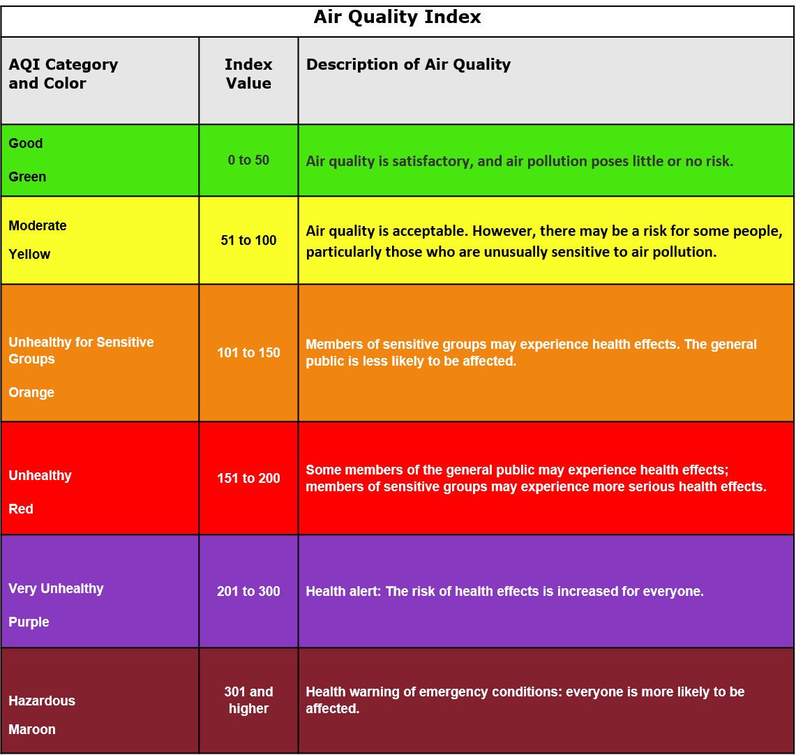
The Environmental Protection Agency monitors the air around the country and compiles an air quality index, or AQI.
The index rates how clean or polluted the air is each day. The EPA uses this measure to keep tabs on five kinds of air pollutants. The main concern from the wildfire smoke is fine particle pollution, or PM2.5. These particles are tiny enough to get deep into the lungs. They can cause short-term problems like coughing and itchy eyes, and in the long run, can affect the lungs and heart.
You can check the real-time air quality in your area using the AirNow map here. The numbers are updated every hour and the site also includes a forecast for the day ahead. The map pulls in measurements from a network of air monitoring stations across the country.
What do the numbers mean?
The index runs from zero to 500. The higher the number, the worse the air quality. That range is broken down into six color-coded categories. Green or yellow — in the zero to 100 range — the air is pretty clear. Once it gets up to orange, the air quality could be a concern for sensitive groups like kids, older adults or those with health conditions.
In the red and purple zones, the air quality is considered unhealthy for everyone. And once it gets to maroon — at 301 or above — pollution levels are hazardous.
At these high levels, take precautions to avoid breathing in the dangerous air. That can mean reducing your outdoor activities, running air purifiers inside and wearing a well-fitting mask like an N95 when you’re outside.
“If you have to exert yourself, exert yourself less. Hydrate more,” said Dr. Leonardo Trasande, who studies environmental health at New York University.
