
With a winter storm bringing ice threats to parts of the Chicago area, many are wondering what exactly does an ice storm warning mean and what's required for such an alert to be issued?
Here's what you need to know in the Chicago area.
Where was an ice storm warning issued?
The National Weather Service issued an ice storm warning for McHenry County early Wednesday morning, with the alert in effect through 6 a.m. Thursday.
Feeling out of the loop? We'll catch you up on the Chicago news you need to know. Sign up for the weekly Chicago Catch-Up newsletter here.
"Significant icing" is expected in the area as forecast models show ice and sleet accumulation up to half-an-inch, along with winds gusting as high as 35 miles per hour.
"Power outages and downed trees are likely due to the ice," the alert states.
According to the NBC 5 Storm Team, some areas could see up to half an inch of ice accumulation, creating dangerous travel conditions on roads.
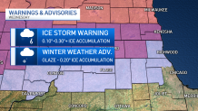
Meanwhile, a winter weather advisory is in effect for northern Cook, DeKalb, DuPage, Kane and Lake counties.
Weather
There, ice projections range from .10 to .20 inches. Some locations could reach higher, depending on temperatures at the time of the storm, in which case additional ice storm warnings may be possible.
Totals are projected to be more of a glaze to the south, with .01 inches expected.
What is an ice storm warning?
According to NWS, ice storm warnings are issued when ice accumulation is expected to reach at least 0.25 inches or higher. They are one of only three winter weather warnings issued in the area, with winter storm and blizzard warnings also on the list.
It's important to note the difference between watches and warning, however.
Typically, a winter storm watch is issued at least 24 hours ahead of a storm, noting that a hazardous weather event has at least a 50% chance of occurring, but many details like its location or exact timing could still be unclear. The only winter watches issued in the Chicago area are winter storm watches and blizzard watches, though blizzard watches are rare.
As a weather event nears, a watch can then be upgraded to a warning or an advisory, which indicates it has an 80% or higher chance of occurring.
"A warning indicates that conditions pose a threat to life or property, and that travel will become difficult to impossible," the NWS says. "An advisory indicates conditions pose a significant inconvenience, and if caution is not exercised, could lead to situations that may threaten life and/or property."
There are only two winter advisories issued in the Chicago area: a winter weather advisory and a freezing rain advisory.
A winter weather advisory is issued for one or more of the following threats: Snow of 3 to 5 inches in 12 hours, sleet accumulation up to .25 inches, freezing rain in combination with sleet and/or snow, or blowing snow.
Why are ice storms so dangerous?
Ice can bring with it a number of hazards, from power outages to dangerous travel.
"Heavy accumulations of ice can bring down trees and topple utility poles and communication towers," the NWs states. "Ice can disrupt communications and power for days while utility companies repair extensive damage. Even small accumulations of ice can be extremely dangerous to motorists and pedestrians. Bridges and overpasses are particularly dangerous because they freeze before other surfaces."
Things like black ice can be deadly on roadways.
What else should you expect with this storm?
According to the NBC 5 Storm Team, rain, sleet and freezing rain will begin to develop in the morning. In some areas, hazardous conditions were already be in place by the morning commute.
By the afternoon, sleet and freezing rain is expected to the north, while heavy downpours can be expected farther south, the NBC 5 Storm Team says. Across the area, the NWS says, a mix of strong winds and wintery precipitation will likely impact the afternoon commute.
That rain will continue to grow heavier in the afternoon and early evening hours, bringing the potential for a few thunderstorms and flooding across parts of the Chicago area. Anywhere from 1-2 inches of rain is expected, though in some locations those numbers could reach up to 3 inches.
"Difficult ravel conditions are possible," the NWS says, adding residents and drivers should "prepare for possible power outages."
Wednesday evening, sleet and steady rain are expected to gradually come to an end, though some precipitation could remain overnight. However, strong winds are expected to persist, and even increase up to 40 mph Thursday.
According to the NBC 5 Storm Team, Wednesday will see a high temperature of around 36 degrees. Thursday, temperatures will be slightly warmer, with highs in the low 40s predicted.
