
A winter weather system bringing Blizzard Warnings to Minnesota and Winter Storm Warnings to Wisconsin is set to arrive in the Chicago area Wednesday morning, with ice, sleet, freezing rain, thunder and winds gusting as high as 35 miles per hour set to impact different parts of the region throughout the day, the NBC 5 Storm Team says.
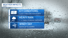
And while the brunt of the winter precipitation will mostly be felt in counties to the north, heavy downpours, freezing rain and damaging winds across the area are expected to result in hazardous driving conditions, the National Weather Service says.
Early Wednesday, the NWS warned of "slippery travel conditions due to freezing rain," for morning commuters across Cook and Will counties in Illinois, as well as Lake and Porter counties in Indiana.
Feeling out of the loop? We'll catch you up on the Chicago news you need to know. Sign up for the weekly Chicago Catch-Up newsletter here.
Here's a breakdown of when and where the winter weather is expected to hit, along with how much rainfall or ice accumulations your area could see.
Ice Storm Warning: McHenry County
According to the National Weather Service, an ice storm warning with "significant icing expected" is in effect beginning at 6 a.m. Wednesday for McHenry County. Forecast models show ice and sleet accumulation up to half-an-inch, along with winds gusting as high as 35 miles per hour.
"Power outages and downed trees are likely due to the ice," an alert from the NWS says.
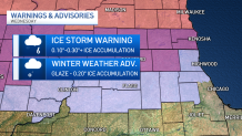
The warning will expire at 6 a.m. Thursday, the NWS says.
Weather
According to the NBC 5 Storm Team, some areas could see up to half an inch of ice accumulation, creating dangerous travel conditions on roads.
In Crystal Lake alone, the NBC 5 Storm Team projects ice accumulation of .46 inches. In Waukegan, the NBC 5 Storm Team projects ice accumulation of up to .38 inches.
Winter Weather Advisory: Northern Cook, DeKalb, DuPage, Kane, Lake, Lee Counties
For much of the Chicago area, the storm is expected to be in the form of freezing rain, heavy downpours, sleet and strong, gusting winds.
In Lee and DuPage counties, a winter weather advisory going into effect at 6 a.m. Wednesday will expire by 3 p.m. However, in Northern Cook, Lake, Kane and DeKalb counties, the advisory will remain in effect until 6 a.m. Thursday.
There, ice projections range .10 to .30 inches, with .31 inches predicted in Elgin, to .18 inches predicted in Lake Forest and Buffalo Grove.
Those totals are projected to be more of a glaze to the south, with .01 inches of ice cover expected in Wheaton.
Winds however are expected to remain strong across the area, with gusts up to 35 mph creating difficult travel conditions.
Weather Timeline
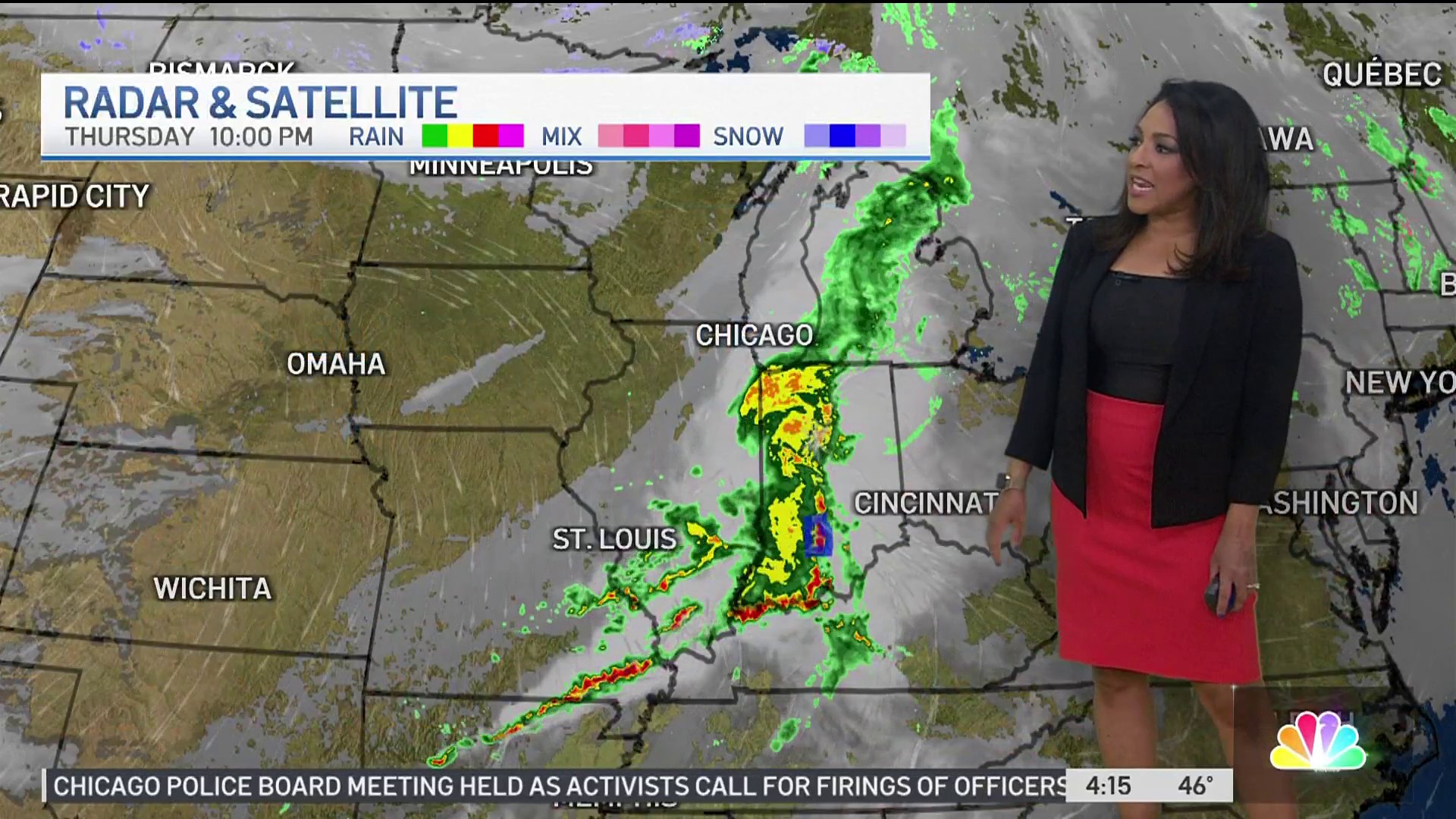
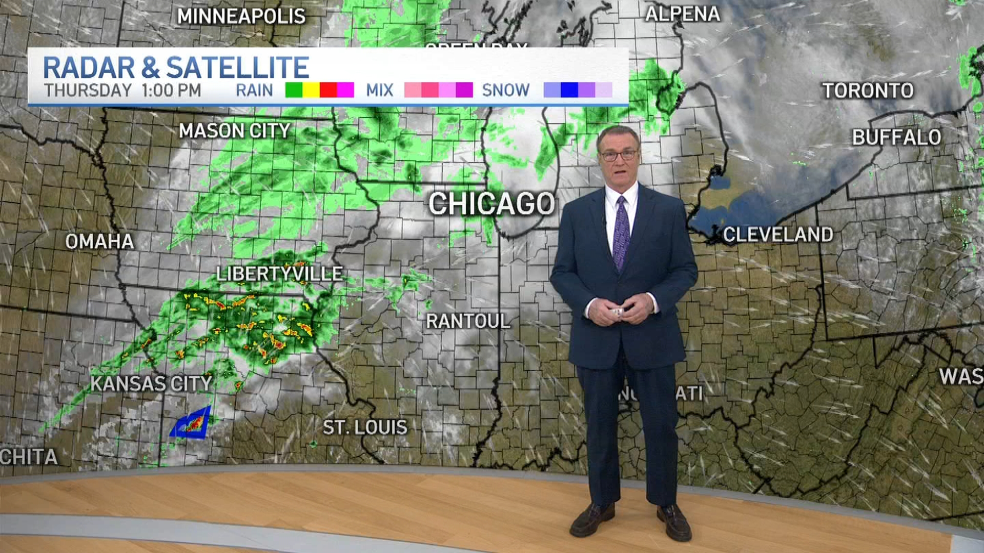
According to the NBC 5 Storm Team, rain, sleet and freezing rain will begin to develop in the morning. In some areas, hazardous conditions could already be in place by the morning commute.
By the afternoon, sleet and freezing rain is expected to the north, while heavy downpours can be expected farther south, the NBC 5 Storm Team says. Across the area, the NWS says, a mix of strong winds and wintery precipitation will likely impact the afternoon commute.
That rain will continue to grow heavier in the afternoon and early evening hours, bringing the potential for a few thunderstorms and flooding across parts of the Chicago area. Anywhere from 1-2 inches of rain is expected, though in some locations those numbers could reach up to 3 inches.
"Difficult ravel conditions are possible," the NWS says, adding residents and drivers should "prepare for possible power outages."
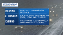
Wednesday evening, sleet and steady rain are expected to gradually come to an end, though some precipitation could remain overnight. However, strong winds are expected to persist, and even increase up to 40 mph Thursday.
According to the NBC 5 Storm Team, Wednesday will see a high temperature of around 36 degrees. Thursday, temperatures will be slightly warmer, with highs in the low 40s predicted.
