Editor's note: Our latest weather story can be found here. Our original story continues below.
Thursday could potentially be an intense weather day across the Chicago area, as ferocious winds could cause downed tree branches and even travel concerns while rain and snow batter the region.
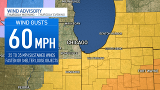
A wind advisory will be in effect Thursday in Grundy and Kankakee counties, as well as southern Will County. All of northern Indiana, including Lake, Porter, LaPorte, Newton and Jasper will also be affected, with wind gusts in excess of 60 miles per hour possible.
Here is a full timeline of what’s expected with the weather disturbance.
Feeling out of the loop? We'll catch you up on the Chicago news you need to know. Sign up for the weekly Chicago Catch-Up newsletter here.
Wednesday Night
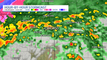
According to the National Weather Service, the opening round of the system could potentially arrive late Wednesday night and into early Thursday morning, with a strong line of showers that could also contain embedded thunderstorms or torrential downpours.
There is also a “low chance” of damaging winds associated with that line of showers, which could sweep across the entire area.
Local


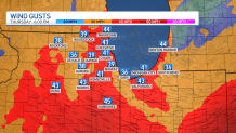
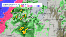
Thursday Morning
Strong winds will start to impact the area in the morning hours, with a wind advisory going into effect in the far southern suburbs and in northwest Indiana.
Sustained winds of 25-to-35 miles per hour are possible throughout the area, but the strongest gusts will likely occur in the advised areas, with gusts in excess of 50-to-60 miles per hour possible.
Areas of central Illinois and central Indiana could see even more dangerous winds.
Travel will be difficult on north-south roads, especially for high-profile vehicles, throughout the day Thursday.
In addition to the violent winds, showers and even isolated thunderstorms are possible in the morning hours as they swirl around an area of low pressure. Rainfall could be heavy at times, significantly impacting the morning commute.
Thursday Midday
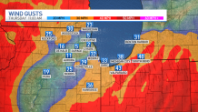
Winds will begin to shift out of the south, though they will still maintain their ferocity, with sustained speeds of 30-to-40 miles per hour in areas covered by the wind advisory.
Gusts will continue to be strong, occasionally surging toward 50 miles per hour.
Rain will also build into the southern suburbs and into northwest Indiana around midday, but the likelihood of thunderstorms will slowly begin to diminish as the day progresses.
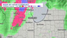
Thursday Afternoon
Rain starts to turn to mixed precipitation and snow in the northwestern and western suburbs, with wet snow possible in areas around Rockford and other parts of northwestern Illinois.
The city’s southern suburbs could still see rain, but fierce winds will be the predominant story as the day goes on, according to forecast models.
Thursday Evening
Wind gusts in excess of 40 miles per hour will still be possible for most of the area, with areas south of Interstate 80 seeing the worst of the dangerous conditions.
Wind speeds should begin to diminish late into the evening, with the advisory ending after dark, according to the National Weather Service.