
That groundhog may have been onto something.
With a Winter Storm Warning and Advisory now in effect bringing ice accumulation, winds gusting as high as 40 miles per hour and heavy snowfall predicted, Thursday in Chicago will look and feel a lot more like winter.
And while some parts of the region could see up to seven inches of snow, totals could change, the NBC 5 Storm Team says, as precipitation types -- whether it be snow, sleet, or freezing rain -- are expected to vary across the area.
Additionally, severe weather across the country in the form of snow to the west and tornadoes to the south is already snarling air travel, with cancellations beginning to impact flights in and out of Midway and O'Hare International Airports.
Feeling out of the loop? We'll catch you up on the Chicago news you need to know. Sign up for the weekly Chicago Catch-Up newsletter here.
Here's a breakdown of the Winter Weather Warnings and Advisories in effect, predicted snow totals and more.
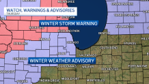
Winter Storm Warnings: McHenry, Lake Counties
According to an alert from the National Weather Service, a winter storm warning that expires at 9 p.m. Thursday at 3 a.m. went into effect for McHenry County, and at 6 a.m. went into effect for Lake County.
Local

According to the alert, heavy snow is expected to fall in McHenry county throughout the day, with accumulations of up to six inches predicted.
Additionally, forecast models showing a light glaze of ice accumulation and winds gusting as high as 40 mph could create dangerous driving conditions.
"The hazardous conditions will likely impact the morning and afternoon commutes," the NWS says.
In Lake County, accumulation totals will be around the same, but more sleet and ice is expected, forecast models show.
According to the NWS, residents there could see ice accumulations of up to one tenth of an inch.
"Conditions will likely impact the afternoon commute," the NWS says.
Winter Weather Advisory: South and North Central Illinois
In Lee, DeKalb, Kane, LaSalle and Kendall Counties, a winter weather advisory in effect until 9 p.m. is also predicted to bring snow, sleet, ice and strong winds, but accumulation totals are lower. According to the NBC 5 Storm Team, snow totals of between one and five inches can be expected.
In DuPage, Grundy, Cook and Will Counties, the advisory will take effect at 6 a.m.
In Kankakee County to the south, much of the precipitation is expected to remain in the form of rain and freezing rain.
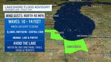
Additionally, a Lakeshore Flood Advisory for Northern and Central Cook Counties in Illinois, as well as Porter County in Northwest Indiana will go into effect at 3 p.m., the NWS says, with waves of up to 10-to-14 feet, and the potential for minor lakeshore flooding.
Timing
According to the NBC 5 Storm Team, between 6 a.m. and noon, a mix of rain, sleet, and freezing rain will hit much of the Chicago area, although that precipitation will likely be in the form of snow across the northern counties.
From 12 p.m. to 3 p.m., the mixed precipitation is expected to change over to snow as winds begin to pick up and temperatures begin to drop into the mid 30s.
By late afternoon through evening, blowing snow showers are expected to be widespread, with wind gusts up to 40 miles per hour.
Thursday night, the snow is expected to gradually come to an end but the winds will remain, the NBC 5 Storm Team says. Friday is expected to be cold and sunny, with colder temperatures in the upper 20s.
Predicted Snow Totals
Forecast models show the highest snowfall amounts are expected to occur in northern Illinois, near the Wisconsin state line and in McHenry and Lake counties, where accumulations could be upwards of six inches.
According to the NBC 5 Storm Team, Waukegan could see up to 7.1 inches of snow when all is said and done.
In Cook, DuPage and DeKalb counties, snow totals are expected to remain between one and four inches, with 3.4 inches predicted to fall at Midway Airport, forecast models show.
Here's a full breakdown of potential snow totals.
