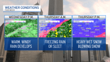
With a powerful winter storm on the horizon, the Chicago area is preparing for heavy rain, snow, sleet and wind before the end of the week.
The storm will likely start as with rain showers before transitioning to ice and wet snow by Thursday afternoon, according to the latest forecast models.
Here is what we know so far as the system approaches the region.
Wednesday Afternoon:
Feeling out of the loop? We'll catch you up on the Chicago news you need to know. Sign up for the weekly Chicago Catch-Up newsletter here.
The storm system will begin to move its way into the Chicago area in the afternoon, bringing rain and high winds, according to forecast models.
In DuPage, La Salle, Kendall, Grundy, Kankakee, Livingston, parts of Cook and parts of Will counties in Illinois, as well as Lake, Porter, Newton and Jasper counties in Indiana, a wind advisory is in effect from 9 a.m. to 6 p.m. Wednesday.
At times, wind gusts could reach 40 to 50 mph, according to the advisory. Weather officials warned small tree limbs could be blown down and power outages are expected.
Local

The anticipated showers are expected to bring 1-to-2 inches of rain to the area, with localized heavier amounts possible, causing potential flooding and slippery road conditions.
Wednesday Night:
Temperatures will begin to drop Wednesday night, with select locations seeing rain transition to freezing rain and sleet around midnight, according to forecasts.
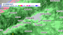
The transition will likely occur from northwest to southeast due to strong northerly winds, meaning that rain is expected to continue overnight into Thursday morning in many locations.
Overnight Thursday:
Rain will transition to freezing rain across the area, starting in the northern suburbs and slowly making its way down through Chicago and then ultimately into the southern suburbs.
The National Weather Service issued a winter storm warning early Thursday morning into the evening for the following Illinois counties: La Salle, Kendall, Grundy, Kankakee, Livingston, parts of Cook, parts of Will. The warning was also issued for Lake and Porter counties in Indiana.
The warning will be in effect from 3 a.m. to 9 p.m. Thursday.
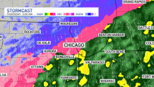
In parts of northern Illinois, snow could potentially begin before sunrise, with the icy mix transitioning to snow in Lake and McHenry counties by the time the sun comes up.
Thursday Morning:
Thursday morning should see snow become more widespread across the area, with the intensity picking up as the morning moves along.
The only places it likely won’t snow before noon are in the far southern suburbs, where freezing rain and mixed precipitation are expected to fall through the late morning to early afternoon.
Thursday Afternoon and Evening:
By the afternoon hours, snow will be falling across the region, with winds picking up and causing limited visibility and hazardous travel conditions in many areas.
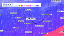
It is not known at this time where the heaviest snowfall amounts will occur, but widespread travel issues are expected, with snow tapering off in the evening hours.
Overall Look
Over the next two days, the Chicago area can expect a mixed bag of weather. Wednesday's warmth and rain showers will give a taste of spring to the region before the freezing rain, sleet and snow move in Thursday.
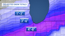
By Friday, snowfall totals are not yet confirmed, though meteorologists expect smaller accumulations of 1-to-3 inches in the northern Chicago suburbs, 3-to-6 inches near and to the west of the city, and around 4-to-8 inches in southern counties and northwest Indiana.