
Parts of the Chicago area could see several inches of snow by Friday morning as a wintry system moves across northern Illinois beginning Thursday afternoon.
A winter weather advisory takes effect across the area Thursday, warning of accumulating snow in some areas, ice and hazardous travel.
The advisory was issued for DeKalb, Kane, Kankakee, DuPage, LaSalle, Kendall, Grundy, Cook and Will counties in Illinois and Lake, Newton, Jasper and Porter counties in Indiana from 12 p.m. Thursday to 6 a.m. Friday. In McHenry and Lake counties, the advisory begins at 3 p.m.
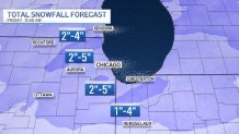
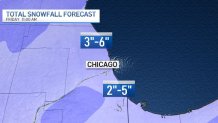
The advisory warns of anywhere from 2 to 5 inches of snowfall, with the highest totals near Lake Michigan in northeast Illinois.
Feeling out of the loop? We'll catch you up on the Chicago news you need to know. Sign up for the weekly Chicago Catch-Up newsletter here.
In Kankakee and parts of northwest Indiana, snowfall rates could reach up to one inch per hour, with a glaze of ice adding to the mix.
Here's a look at the latest totals from the NBC 5 Storm Team:
The advisory warns of hazardous travel conditions across the area as snow and ice make roads slippery, particularly for the afternoon and evening commutes Thursday.
Local

Despite some morning flurries, the main event in terms of snowy weather is expected to get underway Thursday afternoon.
Snowfall accumulations are expected to pile up beginning in the afternoon, with some locations near the Illinois-Wisconsin border potentially seeing up to five inches of snow, according to forecast models.
Lesser-accumulations are possible in other parts of the area.
Another potential issue could arise along U.S. 24 in Illinois and Indiana, with sleet possible in Jasper and Newton counties, as well as Livingston, Ford and Iroquois counties.
Between 1-to-4 inches of snow could fall in the area, but up to one-tenth of an inch of ice is also possible as the storm pushes through.
Snow will eventually end early Friday morning, with some slippery conditions still possible as crews work to clear roadways and sidewalks.
The chance still exists of some lake-effect snow on Friday, but accumulations are unlikely, according to current forecast models.
There is some good news on the horizon after a chaotic week, with warmer temperatures and clear conditions expected on Saturday and Sunday. The highs on both days are expected to rise into the mid-to-upper 30s in Chicago, and the weather will be a precursor to a continued warming trend that will drive highs back into the 40s next week.
