
Two upcoming rounds of snow are threatening to bring more than a foot of snow to some Chicago-area locations, but what exactly you will see with these systems depends on where you live.
Tuesday night and into Wednesday will bring the biggest snowfall of the systems set to hit the area this week.
Storm Team 5 meteorologists broke down what to expect across the Chicago area.
When will the snow begin and how long will it last?
Feeling out of the loop? We'll catch you up on the Chicago news you need to know. Sign up for the weekly Chicago Catch-Up newsletter here.
Precipitation is set to begin, likely as rain, Tuesday afternoon as temperatures may climb into the mid 40s. This will mark the start of the first winter system.
Rain will likely change to snow shortly after sunset as temperatures begin to drop. Snow is expected to then develop over the entire Chicago area, staying heaviest to the south and lightest to north.
The heaviest snowfall will likely occur on Wednesday morning, with a snowfall rate of up to 1 inch per hour falling during that time for many locations. That will likely cause serious travel issues throughout the region, according to forecast models, and residents are urged to postpone unnecessary travel.
Local


Snowy and potentially hazardous driving conditions are expected during the morning commute on any highway south of Chicago, especially in areas like Kankakee County and parts of northwest Indiana.
By Wednesday afternoon, the snow is expected to taper to light snow or flurries, but may not entirely end as the first wave moves out.
Another system could follow closely behind the first wave Wednesday evening and into Thursday, again largely for areas south of Chicago and in northwest Indiana.
This system could continue to dump several additional inches of snow in some locations through Thursday afternoon, before coming to an end by the evening hours.
When do the weather alerts begin?
LaSalle, Grundy, DuPage, Kendall, as well as parts of Cook and Will counties will be under a winter storm warning from 8 p.m. Tuesday through 6 p.m. Thursday, the National Weather Service announced, as 5 to 11 inches of snow is expected to accumulate across the area.
Kankakee County, along with Lake, Porter, Newton and Jasper counties in Indiana, will be under a winter storm warning starting at 10 p.m. Tuesday and continuing through 6 p.m. Thursday.
A separate warning takes effect at midnight for LaPorte County and goes until 6 p.m. Thursday.
A winter weather advisory also begins for parts of Cook, DeKalb and Kane counties at 8 p.m. and continues through 6 p.m. Wednesday.
How Much Snow is Expected?
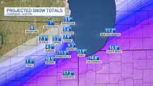
NBC 5 Storm Team meteorologists say snow totals will vary dramatically across the area.
In the first storm, anywhere from 4 to 8 inches is possible for the metro area, while up to 14 inches could be seen in far southern suburbs and parts of northwest Indiana.
In northern suburbs, 1 to 3 inches is expected.
If the second storm follows a similar path to the first storm, which is likely, far southern counties may receive 15 inches or more in total by Thursday night, though those totals don't account for compaction, which could make on-the-ground totals appear less.
Meanwhile, far northern counties will likely receive 1 to 3 inches or less by the time both systems move out.
For areas along Interstate 80, totals look to stay between 5 and 10 inches.
The winter storm warning for LaSalle, Grundy, Will, and parts of Cook County warns of 5 to 11 inches possible through Wednesday, though additional snow may fall outside of the warning window. In DuPage and Kendall, the warning calls for anywhere from 4 to 8 inches of snow.
In Kankakee County in Illinois and Newton, Jasper, Lake and Porter counties in northwest Indiana, the warning calls for accumulations between 8 and 12 inches with the first system and an additional 3 to 6 inches from Wednesday night through Thursday.
The advisory for DeKalb, Kane and northern Cook County calls for total accumulations between 1 and 5 inches of snow.
What about travel?
The National Weather Service says that travel may become “very difficult-to-impossible” on Wednesday and residents are being urged to postpone any unnecessary travel.
The morning and evening commutes Wednesday and Thursday are expected to be impacted by the two systems.
Chicago's Office of Emergency Management and Communications urged commuters to take caution while on the roads during the storms.
The department issued the following winter safety tips for drivers:
- Allow extra time to reach your destination.
- Leave plenty of space between vehicles.
- Have a full tank of gas and let friends and relatives know where you are going.
- Make sure you have an emergency kit in your vehicle.
- Yield to emergency vehicles as well as Streets and Sanitation salt spreaders and plows.
Meanwhile, the Illinois Department of Transportation's Getting Around Illinois website offers a look at current winter conditions across the state.
Using a map, the site tracks which roadways are clear and which are partly, mostly or completely covered with ice or snow.
If you must travel, IDOT recommends:
• Take it slow, especially when approaching intersections, ramps, bridges and shaded areas that are prone to icing.
• Make sure your gas tank is full.
• Keep a cell phone, warm clothes, blankets, food, water, a first-aid kit, washer fluid and an ice scraper in your vehicle.
• Check the forecast and make sure someone is aware of your route and schedule.
• Carry a cellphone and dial *999 in the Chicago area for assistance in case of emergency.
• Reminder: Using handheld phones while driving is illegal in Illinois, unless it is an emergency situation.
• If you are involved in a crash or break down, remain inside your vehicle, which is your safest form of shelter. Exiting your vehicle into live traffic can have fatal consequences.
• Always wear a seat belt, whether you’re sitting in the front seat or back seat. It’s the law.
As for flights, the weather service noted that O'Hare Airport "looks to be right on the edge of the heaviest snow."
"If the snow ends up over the airfield, low visibility would be a good bet," the NWS tweeted. "Airlines and the local officials make the final decisions on how flights would be impacted."
Will my child's school be closed?
Looking to see if your child's school is closed?
There's a way to track school closings across Illinois and Chicago from public schools to private schools to daycares and more.
The Emergency Closing Center tracks closures of Chicago-area schools, businesses, daycare centers and other organizations.
How can I track the snow?
Track the system as it moves through the area live using our Live Doppler 5 radar.
The NBC 5 Storm Team will continue to monitor the weather systems as they develop, and the latest information can always be found on the NBC Chicago app.
