While we’re still enjoying summer in the Northern Hemisphere, the winter could potentially see more snow and precipitation than usual, according to new climate projections from the National Weather Service.
Last week, the NWS’ Climate Prediction Center issued its newest long-lead forecasts for the coming months, examining probabilities of seeing different temperature and precipitation patterns in increments of three months.
NOTE: Meteorologists caution that such long-range predictions are particularly challenging, and the models will continue to change as winter approaches. Events like blizzards and long cold spells could potentially impact seasonal averages as well, experts warn.
In weather circles, “meteorological winter” is defined as the three month stretch between Dec. 1 and March 1, and according to the projections provided by NWS, that period of time could produce some interesting weather in the Chicago area and in northwest Indiana.
Feeling out of the loop? We'll catch you up on the Chicago news you need to know. Sign up for the weekly Chicago Catch-Up newsletter here.
According to projections, the winter months could see above-average precipitation through most of Illinois and Indiana, with that pattern repeating itself through most of the Great Lakes.
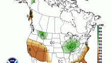
Things could get especially dicey in the three-month stretch between January and March, with just about all of Illinois and Indiana seeing at least a 70% chance of above-average precipitation.
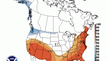
In terms of temperature, NWS’ models have not yet established a pattern, saying that there is a 50/50 chance of either above or below-average temperatures during the winter months.
Last year, the Chicago area experienced a normal winter in terms of temperatures, with above-average readings in December getting balanced out by below-average readings in January and February, the three months that comprise “meteorological winter.”
Parts of northern Illinois received significantly less snowfall than usual, with Rockford finishing with 15.7 inches of accumulation, more than a foot less than it normally receives.
The city of Chicago received 28.6 inches of snow, right around the city’s average.
If you’re a fan of warmer weather, then the fall will likely be your time to shine. According to NWS’ models, above-average warmth is expected from September through November, with above-average temperatures still possible during the month of December. The probability of that does drop, according to the maps.
For those curious, the Old Farmer’s Almanac has called for “unreasonably cold and snowy” conditions this winter in the Midwest, citing long-term temperature and weather patterns over the last 30 years.