
Parts of the Chicago area, particularly those along the lakefront, are under a winter storm watch as several inches of snow are possible Thursday evening and into Friday morning.
The National Weather Service issued the alerts for Central and Southern Cook County, along with Lake County in northwest Indiana Thursday morning and afternoon. The alerts take effect late Thursday evening and continue through noon Friday.
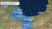
Light snow showers and flurries were expected in parts of the area throughout the day Thursday, but once the system makes its way through, northeast winds will make for lake effect showers that could dump as much as 6 inches of snow along parts of the lakefront.
Feeling out of the loop? We'll catch you up on the Chicago news you need to know. Sign up for the weekly Chicago Catch-Up newsletter here.
The lake effect snow is expected to develop late Thursday evening and continue through Friday morning. Snowfall rates of 1 to 2 inches per hour will be possible in locations under the watch.
The system could dramatically impact morning commutes, with visibility expected to drop to less than one-half a mile and major roadways like Interstates 80, 90 and 94 in northwest Indiana expected to be affected.
In Chicago, the snow will likely stay closer to the lakefront, with some portions not near the lake seeing little to even no accumulation.
Local


Much of the rest of the Chicago area will remain dry.
Check back for the latest developments from the NBC 5 Storm Team as the snow arrives.
