
Want to know when your street will be clear? Here are some ways to track snow removal across Chicago.
To monitor where snow plows are across the city in real time, click here.
City officials announced 286 snow vehicles will be deployed Tuesday evening to respond to expected snow from a winter storm hitting the area overnight.
Initially, Chicago officials said 211 snow plows would hit Chicago streets Tuesday, then added 75 more vehicles once snow started across the area.
The Department of Streets and Sanitation said salt spreaders will be working to keep the city's arterial routes and Lake Shore Drive "safe and passable" for motorists and buses while snow continues to fall.
"Safety is the City's top priority. Though there are less motorist on the road because of the pandemic, those who must travel are urged to take precaution when traveling during inclement weather and drive according to conditions," Chicago officials said.
To monitor winter snow parking restrictions throughout Chicago, click here.
Weather
DSS oversees more than 9,400 lane miles of roadway with salt spreaders, according to a release. The department added that salt is stationed at salt piles throughout Chicago.
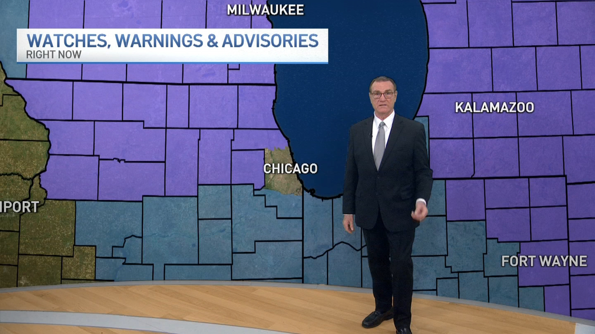
Winter weather alerts are set to take effect across the Chicago area Tuesday afternoon, warning of a potentially dangerous wintry mix that could bring accumulating snow, sleet and freezing rain.
A winter storm warning issued for McHenry and DeKalb counties takes effect at 3 p.m. Tuesday and continues through 9 a.m. Wednesday. That alert was later updated to add northern Cook, Lake and Kane counties in Illinois.
It warns of snow accumulations between 4 and 7 inches and ice accumulations of up to one to two tenths of an inch.
A winter storm watch was also upgraded to a warning for other parts of northern Illinois, just outside of the Chicago area, including Boone, Ogle and Winnebago counties.
Elsewhere in the Chicago area, a winter weather advisory begins at 3 p.m. Tuesday.
The advisory is set to continue until 9 a.m. Wednesday in McHenry, DuPage, LaSalle, Kendall, Cook and northern Will counties in Illinois. For Grundy, Kankakee, southern and eastern Will counties in Illinois and Lake and Porter counties in Indiana, the advisory is in effect through 6 a.m.
For counties under that winter weather advisory, snow accumulations between 1 and 5 inches are possible, with the highest totals expected along and north of Interstate 88. Ice accumulations of up to two tenths of an inch are possible away from the Lake Michigan shoreline and inland.
In LaPorte County in Indiana, a winter weather advisory begins at 6 p.m. CST Tuesday and continues through 6 a.m. Wednesday. It warns of up to 2 inches of snow and ice accumulations of around one tenth of an inch.
Snow showers are set to develop from west to east, starting around 2 to 3 p.m. Widespread snow will likely cover the entire metro area around 6 p.m. Some heavy bursts of snow are possible with quick accumulations of several inches, especially for locations north of Interstate 80.
Since it will snow longer far north and west, that is where higher snowfall totals are expected. Smaller amounts are expected far south, southeast and in northwest Indiana.
Models are predicting varying amounts of snow totals, with some forecasting as low as 2 or 3 inches in far north and northwest counties, and others predicting as high as 10, with a sharp line leaving as low as 1 inch across the rest of the Chicago area. Storm Team 5 meteorologists expect actual amounts to be somewhere in between, with anywhere from 2 to 5 inches expected north and west of the city.
-North and west: 4-8+ inches (higher totals in Rockford, but estimates include parts of Dekalb & McHenry)
-Southern Dekalb, DuPage, Kane, Lake and northern Cook: 2-5 inches
-Southern Lasalle, Kendall, Grundy, Will and southern Cook: 1-3 inches
-Southern Will, Kankakee and northwest Indiana: An inch or less
Snow will gradually taper overnight, but as temperatures increase during the early morning hours, the snow will transition to a period of freezing rain. Light icing accumulations are possible, with less than a tenth of an inch expected for most.
Temperatures will continue to increase to the upper 30s by Wednesday morning as the mixed precipitation transitions to rain.
Rain will be widespread by daybreak, but even though it will be falling as liquid travel concerns will still be there. Any snow or lingering ice will cause slushy and slick road conditions.
Temperatures will fall again Wednesday afternoon as rain gradually comes to an end, but there could be a light mix of snow and freezing rain before the system completely moves out by the late afternoon hours.
Another wintry mix of snow and freezing rain is possible New Year's Day.
