While most of the Chicago area dealt with accumulating snow and slick roads on Wednesday, the wintry conditions are just beginning for the upper Midwest thanks to a parade of weather disturbances that are threatening to deliver more snow for the foreseeable future.
Due to Wednesday’s weather system, portions of the NBC 5 viewing area in northern Illinois and northwest Indiana have reported anywhere from 3-to-4 inches of snow, with some locally-heavier totals reported in Will and DuPage counties.
Even with that in mind, the Chicago area could still potentially see at least some measurable snow through the weekend, and even into next week.
Here’s what we know so far, and residents are reminded that forecasts are subject to change.
Feeling out of the loop? We'll catch you up on the Chicago news you need to know. Sign up for the weekly Chicago Catch-Up newsletter here.
Thursday
Remnants of the disturbance that caused snow accumulations across the area will likely stick around in the morning hours, especially hitting northeastern Illinois and most of northern Indiana, according to forecast models.
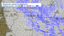
Snowfall likely will not be overly heavy, but could cause slick roads.
By the time all is said and done, another half-inch of snow could fall in most locations, though areas closer to the lake could potentially see a bit of lake-enhancement because of the warm water temperatures on Lake Michigan.
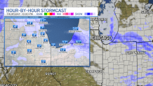
Friday
Another round of snow could potentially arrive Friday morning, though with winds coming out of the south there won’t be any enhancement from Lake Michigan to drive accumulations upwards.
A light dusting is expected in most locations, though some parts of the far northern suburbs could potentially see nearly an inch of snow.
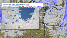
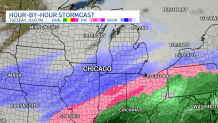
Saturday
A much-more significant disturbance is expected to arrive Saturday morning, spreading snowfall out across northern Illinois as it moves across the upper Midwest.
Some areas on the southern end of the system could see mixed precipitation or even rain, as temperatures are likely going to hover around the freezing mark south of Interstate 80.
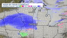
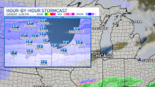
Sunday
That snow is expected to continue as the disturbance slowly slides across the area, with winds shifting back off of Lake Michigan and potentially giving the system a bit of extra fuel to boost snowfall totals.
Over the course of Saturday and Sunday, anywhere between 3-to-5 inches of snow could fall in areas north of Interstate 80, with locally-heavier totals possible in some locations.
South of the interstate snowfall totals are likely to be lighter, with 1-to-2 inches of additional accumulation possible according to current models.
Monday and Tuesday
More snow could potentially fall across the area on Monday, with winds still howling in off of Lake Michigan and leading to a bit more in the way of accumulations.
Just in case residents thought they’d be done with the snow by Monday morning, extended forecast models are showing yet another system driving through the Midwest on Tuesday, which will bring mixed precipitation to southern Illinois and even more snow to portions of northern Illinois and northern Indiana.
Stay tuned to the NBC 5 Storm Team for all the latest weather updates, and download the NBC Chicago app for live radar and forecasts.