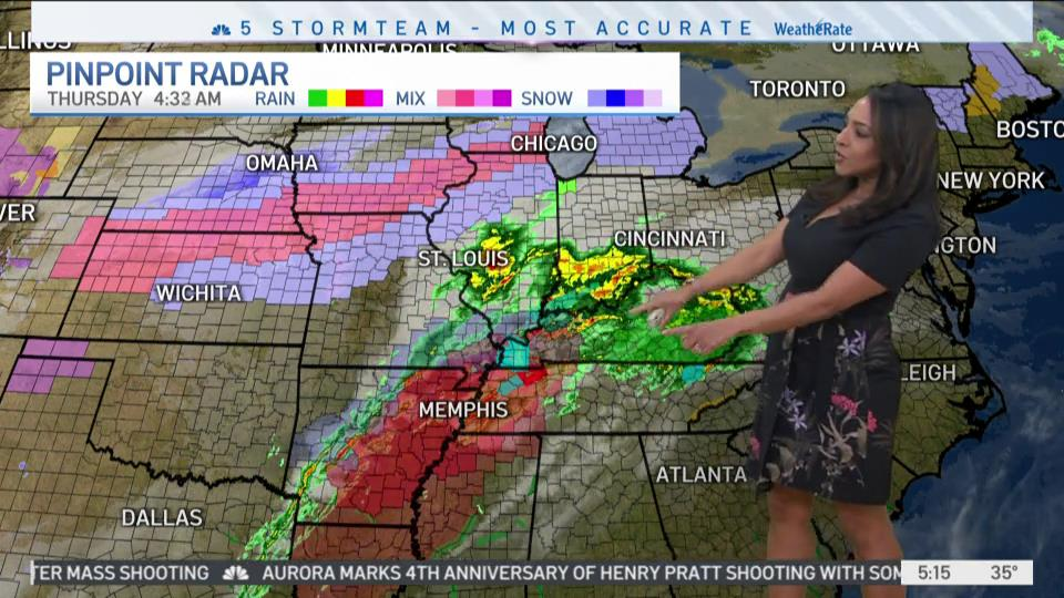
A blast of wintry weather is continuing to impact the Chicago area on Thursday, with snow falling in some communities and liquid precipitation falling in areas further to the south of the city.
Slowly-falling temperatures could potentially cause some ice to form on roadways during the evening commute, and mixed precipitation could also cause travel headaches for motorists as the afternoon and evening roll along.
Here are the latest timing forecasts from the National Weather Service.
Mid-to-Late Afternoon
Feeling out of the loop? We'll catch you up on the Chicago news you need to know. Sign up for the weekly Chicago Catch-Up newsletter here.
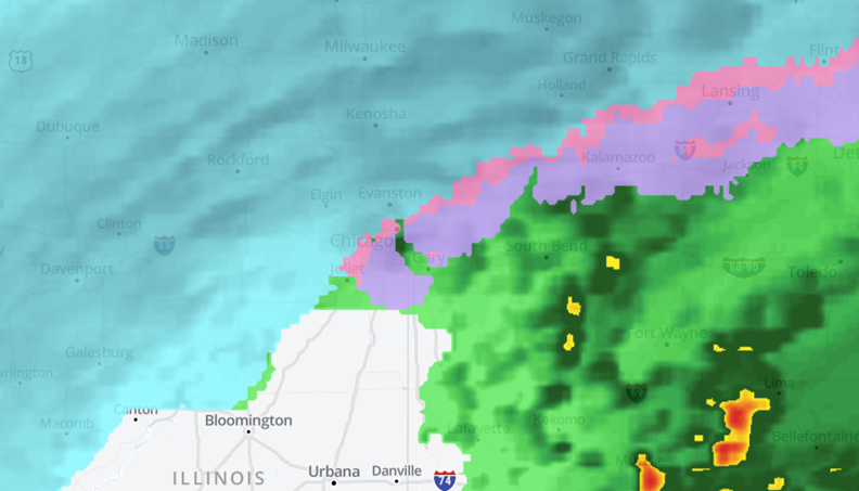
Snow is expected to continue in areas impacted by Thursday’s winter storm warning, including McHenry and Lake counties.
Kane County could also see some snow during that time, though most of the precipitation south of Interstate 88 will likely still be mixed during that time.
Areas further to the south, including Kendall, Grundy, and Will counties, could start to see some mixed precipitation as temperatures continue to fall, but snow isn’t likely in these areas until the sun sets.
The furthest south suburban areas, including Kankakee, Newton and Jasper counties, will likely continue to see rain until dark because temperatures will remain above freezing.
Early Evening
The evening commute could get messy across the area as the rain-to-snow transition continues. Most of the area will start to see snow by around 7 p.m., but the far-southern suburbs could see some icy precipitation, making for dangerous traveling conditions there as well.
Meanwhile, snow will continue to fall in most areas north and west of Chicago, with the city itself potentially starting to see at least some snowfall by the time 6-to-7 p.m. rolls around.
Late Evening
Snow will finally start to fall in areas between Interstate 88 and Interstate 80 after 7 p.m., according to the National Weather Service, with anywhere from 1-to-3 inches of snow possible by 11 p.m.
In areas north of Interstate 88, snow should begin to taper off as the evening moves along, with most precipitation stopping by 11 p.m.
In areas south of Interstate 80, including Livingston and Kankakee counties, icy and mixed precipitation could continue until well into the evening, with perhaps a touch of snow toward the very end of the system as it moves out of the affected area.
Friday Morning
There is a possibility of some lake-effect snow lingering in parts of Chicago and in northwest Indiana into Friday morning, with minor accumulations possible, according to forecast models.
Eventually, winds will shift out of the west, bringing to an end the lake-effect snow in Illinois and Indiana.