The month of January hasn’t exactly felt very winter-like in the city of Chicago, but that’s going to change in a big way this week, as a series of weather disturbances could cause snowy conditions through at least Sunday.
Here is a timeline of how things are shaping up from a weather perspective this week.
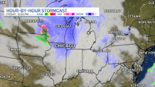
Tuesday-Thursday
While Tuesday will be mostly dry across the region, clouds will begin to build in during the daylight hours, with snow potentially developing in the late evening and into the overnight hours, according to forecast models.
Feeling out of the loop? We'll catch you up on the Chicago news you need to know. Sign up for the weekly Chicago Catch-Up newsletter here.
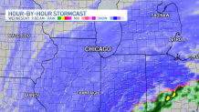
By Wednesday morning, snow will be spread out across the entire upper Midwest, impacting Illinois, Indiana and areas in other states as well. That snow could cause issues for commuters and drivers, and though it likely won’t be overly heavy, there are still possibilities that slick roads could cause problems.
Wednesday evening will see the system beginning to churn out of the area, but thanks to the warm waters of Lake Michigan, and winds shifting out of the north, lake-effect snow could potentially impact areas to the south of the lake in northwest Indiana.
As a result, parts of Indiana could see locally-higher snowfall totals by the time all is said and done Thursday morning, according to forecast models.
Friday
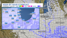
Round two of the snow will arrive Friday in the form of a fast-moving clipper system, which could bring light snow or perhaps some mixed precipitation to the area. Accumulations will in all likelihood be on the lighter side with that disturbance, according to forecast models.
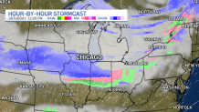
Saturday
Another round of snow will roll in Saturday, as two air masses bump up against one another, according to forecast models. Light snow will likely result from those air masses as they swing through the Midwest, bringing additional accumulations to areas that will have seen snow over the course of several days.
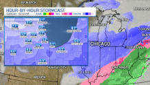
Sunday
Another minor system will move its way through the Midwest on Sunday, bringing yet more snow to the region.
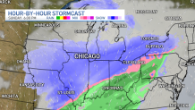
While forecast models are far from dialed in on how much snow could potentially fall, areas of the southern suburbs could be especially-hard hit by snow because of the projected path of the storm systems.
Stay tuned to the NBC 5 Storm Team all week for the latest updates to these forecasts, which could cause snowfall projections to change.