
The Chicago area experienced a bout of severe weather as storms moved through the region, toppling over trees, damaging structures and prompting tornado warnings in multiple communities.
Wind gusts of up to 80 miles hour were reported in some areas.
Here's a look back at the day of weather events as they unfolded:
10:18 p.m.: 2 Tornadoes Touched Down in Illinois, National Weather Service Says
Feeling out of the loop? We'll catch you up on the Chicago news you need to know. Sign up for the weekly Chicago Catch-Up newsletter here.
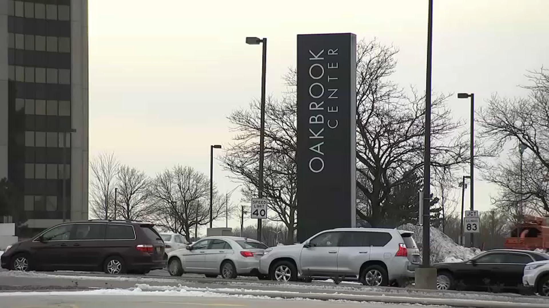
An EF-0 tornado with peak wind speeds of 75 miles per hour touched down in the Chicago suburb of Oak Brook Saturday as severe thunderstorms moved through the region, according to the National Weather Service.
In a tweet, the NWS said it confirmed a brief tornado occurred based on information from local government officials, weather spotters and radar data.
The tornado ranked as an EF-0, the lowest level on the six-tier Enhanced Fujita scale. Traveling approximately 1.9 miles with a maximum width of 60 yards, it snapped tree branches, uprooted trees and tore the roof off a golf course bathroom.
Local
Severe weather also struck the Rockford area where a second brief tornado occurred, traveling approximately half a mile over the course of one minute. Also ranked an EF-0, it brought winds of 80 miles per hours and caused several trees to be uprooted.
Read more information here.
8:51 p.m.: Thunderstorms Lead to Building Collapse in Rockford: Fire Officials
Firefighters in Rockford responded to a building collapse that occurred as a result of thunderstorms in the area Saturday evening, according to authorities.
In a tweet at approximately 6:30 p.m., the Rockford Fire Department said it was on scene of a building collapse near Broadway and 9th Street. It wasn't immediately known if anyone was inside the building at the time of collapse or if injuries occurred.
7:56 p.m.: Chicago Red Stars, Fire Both in Weather Delays
Both of Chicago's professional soccer teams are on the pitch tonight, but both are now under a weather delay due to storms rolling through the area.
The Red Stars, taking on Racing Louisville at SeatGeek Stadium, went into a delay after a lightning strike.
The Fire, playing the New York Red Bulls at Soldier Field, went into a delay a short time later:
7:45 p.m.: Tornado Watch Extended in Four Illinois Counties
A tornado watch has been canceled for several counties, but has been extended to 10 p.m. in four others, including Cook County.
According to the National Weather Service, DuPage, Cook, Will and Kankakee counties will remain under that watch through 10 p.m. due to the persistent threat of thunderstorms in the area.
Grundy, Kane, Kendall and McHenry counties will all see their respective tornado watches canceled, according to the National Weather Service.
7:43 p.m.: Severe Thunderstorm Warning Issued in Kankakee County
A severe thunderstorm warning has been issued for southeastern Kankakee County, along with north-central Ford County and northern Iroquois County until 9 p.m.
A storm, packing 60 mile-per-hour wind gusts and quarter-size hail, is moving to the northeast at 35 miles per hour.
The strongest part of the storm is expected to hit Ashkum and Gilman, officials said.
Kankakee, Watseka and Momence could also see impacts from the storm.
7:14 p.m.: Tornado Watch Canceled in Handful of Counties, but Remains in Effect Elsewhere
A tornado watch has been canceled in DeKalb and LaSalle counties, but remains in effect in 11 different counties until 8 p.m.
The watch was also canceled in Boone, Lee, Ogle and Winnebago counties.
It remains in effect in McHenry, Kane, DuPage, Cook, Kendall, Grundy, Will and Kankakee counties until 8 p.m.
7:09 p.m.: Severe Thunderstorm Warning Issued in Will, Kankakee Counties
A severe thunderstorm warning has been issued in parts of Will and Kankakee counties until 8:15 p.m.
According to the National Weather Service, the storm will impact south-central Will County and western Kankakee County.
The storm is located seven miles east of Dwight, and is moving to the northeast at 40 miles per hour.
The storm is producing wind gusts of up to 60 miles per hour, and is expected to impact Kankakee, Bourbonnais and Peotone.
6:58 p.m.: New Severe Thunderstorm Warnings Pop Up in Several Areas
Severe thunderstorm warnings are popping up all over the NBC 5 viewing area, with two more being issued in just the last few minutes.
The first was issued in southeastern Livingston County, as well as Ford County and western Iroquois County. That will expire at 8 p.m., with 60 mph wind gusts and nickel-size hail possible.
Another warning has been issued in southeastern DuPage County until 7:30 p.m,. with wind gusts of up to 60 miles per hour possible.
That storm is located near Plainfield, and is moving to the northeast at 40 miles per hour.
6:52 p.m.: Severe Thunderstorm Warning Issued for Will County
A new severe thunderstorm warning has been issued for all of Will County until 7:30 p.m.
According to the National Weather Service, the storm is packing nickel-size hail and wind gusts of up to 60 miles per hour.
A line of storms stretching from Boulder Hill to near Coal City is moving to the northeast at 50 miles per hour.
Aurora, Joliet, Naperville and Bolingbrook are among the communities in the line of the storms.
6:51 p.m.: Storm Rips Through Chicago Area, Downing Trees and Damaging Roofs
From downed trees to blown off roofs, several instances of damage were reported Saturday evening following storms that moved through portions of the Chicago area.
Wind gusts reached 65 miles per hour in suburban Plainfield, where an irrigation system apparently blew into a fence, according to storm damage reports from the National Weather Service.
To the northeast, in Oak Brook, a roof was blown off a free-standing bathroom, which was carried approximately 100 feet away, as shown in photos. In addition, a large oak tree and several downed tree limbs were reported near the Hilton Chicago Oak Brook.
The weather system also caused power outages in Rockford, where multiple traffic lights were rendered inoperable. At least one intersection was closed due to storm damage, according to Rockford police.
You can find the latest details here.
6:43 p.m.: Flood Advisory Issued in McHenry County
A flood advisory has been issued in McHenry County due to heavy rainfall, according to the National Weather Service.
Flooding in low-lying areas and poor drainage areas is possible through at least 9:45 p.m., officials said.
Belvidere, Harvard, Poplar Grove, Cherry Valley, Capron and Timberlane could all see flooding due to the heavy rainfall that has occurred, and that still may yet occur this evening.
6:33 p.m.: More Than 1,200 ComEd Customers Without Power
As of 6:21 p.m., more than 1,200 ComEd customers are without power after strong-to-severe thunderstorms moved through the area, with more potentially on the way.
Most of the outages have been reported in Winnebago County, with 786 customers affected. More than 200 are also without power in Whiteside County.
Select customers in Lake, Cook and Will counties are also impacted, the utility said.
Earlier Saturday, additional resources were positioned in areas that could be hit by severe weather, with the utility looking to combat outages quickly.
6:27 p.m.: Severe Thunderstorm Warning Issued in Kendall, Grundy Counties
A new severe thunderstorm warning has been issued for all of Kendall and Grundy counties in Illinois until 7:15 p.m., according to the National Weather Service.
North-central Livingston County is also included in the warning.
A line of severe thunderstorms is currently extending from six miles south of Newark to near Cornell, moving to the northeast at 40 miles per hour.
Wind gusts of up to 60 miles per hour and quarter-size hail are possible in numerous communities, including Coal City, Braidwood, Dwight, Gardner, Channahon and Minooka.
6:19 p.m.: Tornado Warning Canceled in Boone, McHenry Counties
A tornado warning for northwestern McHenry County and northern Boone County has been canceled after it moved out of the area.
A tornado watch remains in effect for northern Illinois through 8 p.m.
6:03 p.m.: Severe Thunderstorm Warning Issued in LaSalle County
An earlier severe thunderstorm warning in LaSalle County was allowed to expire, but a fresh warning has now been issued for east-central portions of that county, along with northwestern Livingston County.
The warning will run through 6:45 p.m., with a storm packing wind gusts in excess of 60 miles per hour moving through the area.
Streator, Pontiac and Long Point are all in the path of the storm, according to officials.
5:58 p.m.: Severe Thunderstorm Warning Issued for Several SW Suburban Counties
A severe thunderstorm warning has been issued for parts of LaSalle, Kendall and Grundy counties until 6:45 p.m., according to the National Weather Service.
According to officials, northeastern LaSalle County, southwestern Kendall County and northern Grundy County are impacted by the warning.
A storm, located near Ottawa, is moving the northeast at 40 miles per hour, with wind gusts of up to 60 miles per hour and quarter-size hail reported.
Marseilles, Seneca, Lisbon, and Wedron are among the communities that could be hit by the storm.
5:48 p.m.: Tornado Warning Issued for Parts of Boone, McHenry Counties
A tornado warning has been issued for northwestern McHenry County and northern Boone County until 6:30 p.m.
According to the National Weather Service, rotation was indicated on Doppler radar in a cell that's located near Timberlane. That storm is moving to the northeast at 30 miles per hour.
The storm will be near Timberlane at 5:55 p.m., and near Poplar Gorve at 6 p.m.
Residents are urged to take shelter IMMEDIATELY.
5:36 p.m.: Severe Thunderstorm Warning Issued in LaSalle County
Another severe thunderstorm line has formed to the southwest of the Chicago area, and in response the National Weather Service has issued a warning for central LaSalle County.
That warning will run through 6 p.m., officials said.
The storm, part of a cluster which formed near Peoria and Bloomington, is located near Wenona, just west of Streator, and is moving toward the northeast at 50 miles per hour.
Wind gusts of up to 60 miles per hour and quarter-size hail are possible.
Another cell in that line is currently under a warning near Bloomington, officials said.
5:15 p.m.: Severe Thunderstorm Warning Issued for Rockford Area
A severe thunderstorm warning is now in effect in several communities near Rockford on Saturday afternoon.
The warning covers all of Winnebago County, as well as eastern Ogle County and northwestern Boone County, according to the National Weather Service.
The warning will expire at 6 p.m.
The storm impacting the area could pack wind gusts in excess of 60 miles per hour, as well as quarter-size hail.
5:12 p.m.: Dime-Size Hail Reported in DuPage County
The latest "local storm report" from the National Weather Service comes from a trained weather spotter, who observed dime-size hail in suburban Darien.
The hail, which was approximately 0.7 inches in diameter, was observed at the intersection of Plainfield Road and Cass Avenue.
5:06 p.m.: White Sox Game Delayed by Severe Weather
The Chicago White Sox game at Guaranteed Rate Field has been halted due to severe weather, with teams coming off the field and the tarp being rolled out by grounds crew.
It is unclear how long the delay will last, but the game is now official having passed the top of the fifth inning.
The Sox currently lead 4-0 in the top of the sixth inning.
5:01 p.m.: Tornado Warning Canceled; Watch Remains in Effect
A tornado warning that was issued for parts of DuPage and Cook counties has been canceled after Doppler radar found that rotation within the storm had stopped, officials said.
A tornado watch does remain in effect for most of northern Illinois and the Chicago area until 8 p.m.
4:51 p.m.: Tornado Warning Issued for Parts of Cook, DuPage Counties
A tornado warning has been issued for east-central DuPage County and central Cook County by the National Weather Service after Doppler-radar indicated rotation inside a cell.
According to the National Weather Service, the cell is located over Oak Brook as of 4:52 p.m., moving to the northeast at 25 miles per hour.
A tornado has not touched down or been confirmed by spotters, but radar has indicated rotation in the cell.
4:45 p.m.: Just One Severe Thunderstorm Warning Still in Effect
Although more storms are starting to fire to the south and west of Chicago, all but one of the severe thunderstorm warnings that were put into effect on Saturday afternoon have expired.
The lone warning that remains ongoing is for a cell impacting northwestern Will County, as well as all of DuPage County and western Cook County.
The storms were located along a line extending from Mount Prospect to Clarendon Hills to Orland Park, moving to the northeast at 40 miles per hour.
The storms have packed wind gusts in excess of 60 miles per hour, which can damage roofs, siding and trees.
4:40 p.m.: More Storms Developing Behind Current Lines
As severe thunderstorms continue to sweep through the Chicago area, new cells are beginning to form behind the initial line.
According to the National Weather Service and NBC Live Doppler 5 radar, new cells are beginning to form near Dixon and near Peoria, and could potentially sweep towards the Chicago area as the evening moves along.
4:32 p.m.: Breathtaking Wind Gust Reported in Plainfield
A trained weather spotter in suburban Plainfield recorded a wind gust of 65 miles per hour during Saturday’s storms.
A severe thunderstorm warning remains in effect for DuPage, Will and Cook counties.
4:27 p.m.: ComEd Prepares for Possible Power Outages as Storms Move In
With a tornado watch in effect for the majority of the Chicago area and the possibility of severe thunderstorms, ComEd is urging residents to take precautions and positioning crews in the event of potential power outages.
Wind gusts of up to 60 miles per hour and quarter-size hail have been reported with storms that occurred Saturday afternoon, and more are possible in the evening hours, according to the National Weather Service.
"We are positioning our people and equipment to respond quickly and safely to any power outages that result from this storm,” Terence Donnelly, president and COO of ComEd, stated in a news release. “We continue to make investments to harden the power grid and improve resilience to reduce the impacts a storm like this can have on our customers.”
The utility also provided some tips and advice to residents on how to prepare for storms, which you can find here.
4:23 p.m.: Ogle, Lee Counties Get Severe Thunderstorm Warning
A new severe thunderstorm warning has been issued for Ogle and Lee counties in Illinois
The storm is tracking to the northeast, potentially putting some parts of the NBC 5 viewing area in the path. We will continue to update this story as it develops.
4:14 p.m.: Severe Thunderstorm Warning Issued for Four Counties
The National Weather Service has issued a new severe thunderstorm warning for several suburban counties as a line of powerful thunderstorms pushes through the area.
The warning includes all of DuPage County, eastern Kendall County, western Cook County and northwestern Will County, and will expire at 5:15 p.m.
The storms could pack wind gusts in excess of 60 miles per hour.
The storms could impact Carol Stream, Glendale Heights, Naperville, Romeoville, Arlington Heights and Woodridge, among other communities.
4:09 p.m.: Cook County Added to Tornado Watch
A tornado watch for northern Illinois now includes Cook County, according to the National Weather Service.
The watch also includes McHenry, DeKalb, Kane, DuPage, LaSalle, Kendall, Grundy, Will and Kankakee counties, and remains in effect until 8 p.m.
3:52 p.m. Severe Thunderstorm Warning Issued for 3 Counties
The National Weather Service has issued a severe thunderstorm warning for parts of Livingston, Grundy and Will counties until 4:30 p.m.
According to the alert, all of Grundy County, north-central Livingston County and west-central Will County are under the warning.
Wind gusts of up to 60 miles per hour and quarter-size hail have been reported with the storms, and the cell is moving to the northeast at 50 miles per hour.
3:20 p.m.: Line of Thunderstorms Continues to Form in Northern Illinois
As of 3:20 p.m., a line of thunderstorms has begun to form to the west of the NBC 5 viewing area, with large cells forming near Dixon and Ottawa.
According to the National Weather Service, some of the storms could be severe, and are moving to the northeast at 50 miles per hour.
The storms could generate small hail, brief heavy downpours and isolated tornadoes, along with damaging winds.
Tornado Watch Issued for Most of Chicago Area, Northern Illinois
The National Weather Service has issued a tornado watch for most of the Chicago area.
The watch includes 16 Illinois counties, including nine in the NBC 5 viewing area. McHenry, DeKalb, Kane, DuPage, LaSalle, Kendall, Grundy, Will and Kankakee counties are all in the watch, which will run through 8 p.m.
According to the National Weather Service, severe thunderstorms are possible throughout Illinois and northwest Indiana on Saturday afternoon and into the evening hours.
Some of those storms could potentially cause damaging straight-line winds, hail, heavy rain and even isolated tornadoes.
Chicago-Area Residents Asked to Delay Showers, Laundry Ahead of Severe Weather
Chicago-area officials are asking residents to delay taking showers or washing dishes in an effort to leave room in the region’s sewer system ahead of potential severe weather on Saturday.
The Metropolitan Water Reclamation District of Greater Chicago has issued an “overflow prevention alert” on Saturday ahead of a series of showers and thunderstorms that are expected to impact the region.
The alert is designed to help maintain enough room in the region’s sewer system, with extra water anticipated to make its way into sewers because of the inclement weather.
