
The Illinois Emergency Management Agency is asking residents to prepare for the upcoming weekend snowstorm and dropping temperatures.
State and local emergency officials urged people in a release to take time before the major anticipated snowfall to prepare families, homes and vehicles for a storm.
“This weekend, if weather impacts your area, please take a moment to check on your neighbors,” IEMA Director Alicia Tate-Nadeau said. “46% of individuals expect to rely a great deal on people in their neighborhood for assistance within the first 72 hours after a disaster. Send a text or make a call to ensure they have everything they need to survive this winter storm.”
The IEMA recommended that residents do the following to prepare:
- Understand the various weather alerts
- Build a home emergency kit with items such as food, water, medications, a weather radio, flashlight and spare batteries
- If travel is necessary, stock a vehicle with emergency items such as a first aid kit, phone charger, batteries, extra clothes, jumper cables, kitty litter or sand, a flashlight and a snow scraper
- Charge cell phones before the storm
- Create and discuss an emergency plan with the family
- Take steps to prevent frozen water pipes
The Chicago area will now be under a winter storm warning Saturday as the second major snowstorm of the week threatens to dump up to 9 inches of snow, possiblly even more, on some parts of the area.
A potentially significant storm has set its sights on northern Illinois, likely bringing several inches of snow just days after much of the area saw its biggest snowfall of the season so far.
Weather
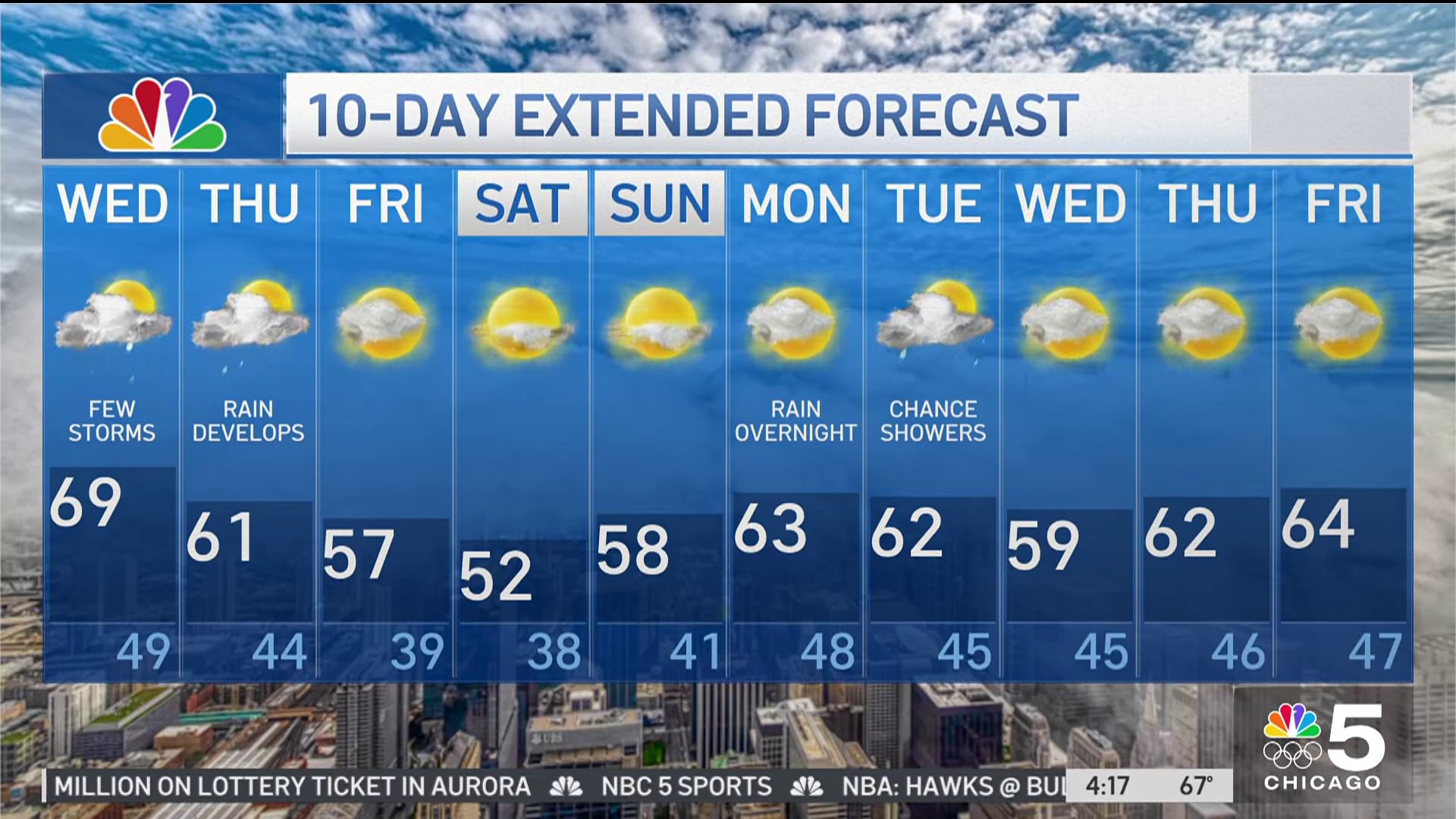
A winter storm watch that had been issued for the entire Chicago area was upgraded to a storm warning Friday afternoon.
In LaSalle County the warning begins at noon Saturday and continues through 6 p.m. Sunday, though the system could begin with a short period of freezing rain before transitioning to snow. In McHenry, Lake, DuPage, Cook, DeKalb, Kane, Kendall, Kankakee and Will counties in Illinois, and Lake County in Indiana, the warning begins at 3 p.m. Saturday and continues through 6 p.m. Sunday.
The alert warns of "heavy wet snow" and wind gusts of up to 30 or 35 mph. Accumulations of 5 to 9 inches or higher are possible.
A winter storm watch remains in effect for Newton and Jasper counties in northwest Indiana from Saturday afternoon through Sunday morning, warning of 3 to 7 inches of snow possible, with some locations seeing higher totals.
Across the area, hazardous travel conditions are expected, according to the weather alerts.
While there is still plenty of uncertainty surrounding the storm, early predictions indicate that snow will develop later in the afternoon. It may start as an icy mix initially then become steady heavy snow in the evening.
For far west and southwest locations, just outside of the Chicago metro area, precipitation looks to start between 2 and 4 p.m.
As the storm inches into the Chicago area, west and southwest counties are expected to see the system move in between 3 and 5 p.m.
Areas north and northwest of Chicago and the city itself, along with parts of northwest Indiana, will likely see things begin anytime between 4 and 7 p.m.
A period of moderate to heavy snow is expected across the area Saturday night. This is likely when the snow will be its most intense, before things begin to taper off in intensity overnight.
The winter storm watch warns of heavy, wet snow and strong winds that could cause low visibility and snow-packed roads, making travel conditions dangerous.
Initial projections show totals could be between 4 to 8 inches by dawn. An icy mix is possible far south toward the Kankakee River Valley which may limit totals.
Though things will lighten during the morning hours, how intense the snow will stay and for how long remains unclear as of Friday. There's likely to continue to be travel impacts during the morning hours.
There is again another chance for lake effect snow on Sunday following the storm, which could bring additional accumulations of 1 to 2 inches to areas along Lake Michigan.
The winter storm watch will continue through 6 p.m. Sunday for counties north of I-80 and by the lake, but only until 12 p.m. Sunday for those south of I-80 and in the western portion of the region.
The lake effect snow could continue into Monday morning, initial forecasts indicate.
