
Update: As of Thursday morning, the latest snowfall projections and timing of the storm can be found here. Our Wednesday story continues below.
Winter in Chicago is about to make an abrupt return over the next few days in the form of wind gusts up to 50 miles-per-hour, dropping temperatures and snow accumulations of up to six inches, the NBC 5 Storm Team says.
Here's a breakdown of when the winter weather is projected to hit, how much snow the Chicago area could see and when.
Wind Advisory Wednesday
Feeling out of the loop? We'll catch you up on the Chicago news you need to know. Sign up for the weekly Chicago Catch-Up newsletter here.
According to the NBC 5 Storm Team, a wind advisory bringing strong, sustained winds of 20-to-25 miles per hour and gusts as high as 50 mph is in effect for the entire Chicago area through noon. Forecast models show the strongest gusts can be expected throughout the morning commute, between through 10 a.m.
Early Wednesday, winds at O'Hare airport clocked in at around 36 mph, and photos and video from across the Chicago area showed emergency crews on the scene of several downed trees and branches.

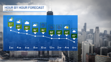
Overnight rain showers are expected to come to an end Wednesday morning, the NBC 5 Storm Team says, as much of the day is predicted to be cloudy, windy and dry.
Additionally, Wednesday's warm high of around 50 degrees was hit in the wee morning hours, and temperatures are expected fall to the mid 30s to low 40s by 4 p.m., forecast models show.
Where and When Will the Snow Hit Thursday?
Local

Snow moving in from the west is expected to return to the area late Wednesday night into Thursday, the NBC 5 Storm Team says, with a winter weather watch for north central and northeast Illinois going into effect at 3 a.m.
According to the National Weather Service, a wintery mix of freezing rain, sleet and winds gusting as high as 40 mph are likely to create slippery, potentially hazardous travel conditions for much of the Chicago area, during both the Thursday morning and evening commutes.
In Lake and McHenry counties, a winter storm watch will go into effect at 3 a.m., with winds of up to 40 mph and the potential for heavy snow accumulations between three and six inches. Total accumulations could exceed six inches in some places, along with minor ice accumulations.
According to the NWS, both watches are set to end at 9 p.m. Thursday.
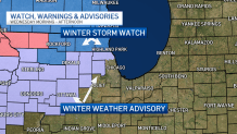
DeKalb, DuPage, Kane, Kendall and Lasalle counties could see between two and four inches of accumulation.
According to the NBC 5 Storm team, the snow is expected to begin after the morning commute, potentially snarling roads as drivers hit the roads in the afternoon.
Additionally, temperatures are expected to fall below freezing by Thursday night, with highs in the low-to-mid 30s.
Friday Through the Weekend
As that system moves out, even colder temperatures expected Friday, with below-average highs in the upper-20s throughout the Chicago area.
But there's some good news, too: High temperatures will rebound quickly over President's Day weekend, with sun and highs rising back into the 40s by Saturday. According to the NBC 5 Storm Team, temperatures are expected to remain in the 40s through Sunday.
