
Flight cancelations to and from Florida airports are piling up as residents and visitors are hoping to escape the state before Hurricane Ian, now a powerful and dangerous Category 4 storm, is forecast to make landfall Wednesday.
As of early Wednesday morning, Orlando and Miami airports reported more than 1,100 flight cancellations, according to Flight Aware. As of Tuesday evening, Tampa International Airport had suspended operations completely.
Across O'Hare and Midway International Airports Wednesday, more than three dozen flights to and from Florida had already been canceled.
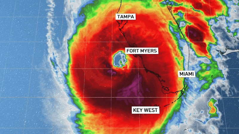
With maximum sustained winds at 155 mph, 2 mph short of a Category 5 hurricane, Ian is expected to cause devastating storm surge, catastrophic winds and flooding along the state's heavily populated Gulf Coast from Bonita Beach to the Tampa Bay region, the National Hurricane Center in Miami said in a 6:35 a.m. advisory Wednesday.
Feeling out of the loop? We'll catch you up on the Chicago news you need to know. Sign up for the weekly Chicago Catch-Up newsletter here.
The storm is centered about 65 miles west-southwest of Naples and is moving north at a speed of 10 mph.
Ian made landfall as a Category 3 storm Tuesday in Cuba just southwest of the town of La Coloma in the Pinar Del Rio province, bringing down the electricity grid and leaving the entire island without power.
Hundreds of thousands of Floridians faced mandatory evacuation orders Tuesday in anticipation of a powerful storm surge, high winds and flooding rains. The hurricane center predicted Ian would roar ashore on Florida's southwest coast on Wednesday afternoon. Many rushed to board up their homes and move precious belonging up to higher floors before fleeing.
“You can’t do anything about natural disasters,” said Vinod Nair, who drove inland from the Tampa area Tuesday with his wife, son, dog and two kittens seeking a hotel in the tourist district of Orlando. “We live in a high risk zone, so we thought it best to evacuate.”
Ian’s slowed over the Gulf, enabling the hurricane to grow wider and stronger. Winds exceeding tropical-storm strength of 39 mph had already reached Florida by 3 a.m. Wednesday and hurricane-force winds were expected in Florida well in advance of the storm's eyewall moving inland, the Miami-based NHC center said.
"The impacts are going to be far, far broader than just where the eye of the storm happens to make landfall," Gov. Ron DeSantis said at a news conference Tuesday. "In some areas there will be catastrophic flooding and life-threatening storm surge."
Forecasters said the storm surge could reach 12 feet if it peaks at high tide. Rainfall near the area of landfall could top 18 inches .
DeSantis urged people to prepare for extended power outages, and to get out of the storm's potential path.


“It is a big storm, it is going to kick up a lot of water as it comes in," DeSantis said at a news conference Tuesday in Sarasota, a coastal city of 57,000 in the storm's projected path. "And you’re going to end up with really significant storm surge and you’re going to end up with really significant flood events. And this is the kind of storm surge that is life threatening."
The National Hurricane Center expanded its hurricane warning along more than 200 miles of the state's Gulf Coast, from Collier County to the Anclote River, just north of Tampa and Clearwater.
On the forecast track, the center of Ian is expected to pass west of the Florida Keys early Wednesday before approaching the west coast. The center of Ian is then forecast to move over central Florida Wednesday night and Thursday morning and emerge over the western Atlantic by late Thursday.
Fort Myers is in the hurricane zone, and Tampa and St. Petersburg could get their first direct hit by a major hurricane since 1921.
A tropical storm warning was in effect for Indian Pass to the Anclote River, all of the Florida Keys, Flamingo to South Santee River, Flamingo to Chokoloskee, Lake Okeechobee, Florida Bay and for southeastern Florida from south of Boca Raton.
A storm surge warning was in effect for the Lower Florida Keys from Big Pine Key westward to Key West, Suwannee River southward to Flamingo, Tampa Bay, the Dry Tortugas, the Flagler/Volusia Line to the mouth of the St. Mary's River, and the St. Johns River.
A storm surge watch is in effect for Florida Bay, the mouth of St. Mary's River to South Santee River, and south the Florida Keys from Card Sound Bridge westward to east of Big Pine Key.
“People on the barrier islands who decide not to go, they do so at their own peril,” Roger Desjarlais, Lee County’s county manager, said early Tuesday. “The best thing they can do is leave."
As many as 300,000 people may be evacuated from low-lying areas in Hillsborough County alone, county administrator Bonnie Wise said. Some of those evacuations began Monday afternoon in the most vulnerable areas, with schools and other locations opening as shelters.
“We must do everything we can to protect our residents. Time is of the essence,” Wise said.
Lee County -- where Fort Myers is on Florida’s southwest Gulf Coast -- also issued mandatory evacuations early Tuesday for low-lying areas including Fort Myers Beach, Sanibel and Bonita Beach, where about 250,000 people live, after forecasters expanded the hurricane warning area.
“With the kind of tidal surge we’re talking about, it would not be uncommon for both islands to be overwashed, and it’s a dangerous place to be,” Desjarlais said. We cannot by law force people off the islands, but we strongly recommend that they go.”
DeSantis said about 2.5 million people were under some type of evacuation order in the state.
Tampa International Airport suspended all operations Tuesday afternoon due to the hurricane. Travelers were advised to contact their airline for information. American Airlines, meanwhile, reduced fares for flights out of 20 airports in the region that may be impacted by the storm. The airline was also waving fees for checked baggage and carry-on pets to help those in the area to evacuate.
Meanwhile flash flooding and urban flooding was possible with rainfall across the Florida Keys and the Florida peninsula through mid-week, NHC forecasters said. A few tornadoes are possible into Tuesday across the Florida Keys and the southern and central Florida peninsula.
Monroe County Emergency Management officials said they were working to advise residents on specific details about the impacts from Ian.
In South Florida, schools in Miami-Dade and Broward were announcing closures this week due to Ian. All schools and offices in the Monroe County School District were closed Tuesday and would remain closed Wednesday due to the impacts of Hurricane Ian.
Florida Power & Light was preparing more than 13,000 workers to assist with their response to Hurricane Ian, company officials said Monday.
The power company said they were pre-positioning workers and supplies to respond to any outages from the hurricane, which was forecast to possibly make landfall along Florida's west coast later this week.
Although South Florida likely won't take a direct hit from Hurricane Ian, flooding was expected throughout the area over the next couple days.
A flood watch was issued for most of South Florida and remained in effect until Thursday morning.
Miami-Dade County crews have been working since last week conducting pre-storm inspections and lowering water levels across the county, Mayor Daniella Levine Cava said in a news conference Tuesday.
The City of Miami opened its Emergency Operations Center at 9 a.m. Tuesday to deal with expected flooding from Ian.
Miami Mayor Francis Suarez reassured residents that all permanent water pumps are working, and seven additional portable pumps will be installed, as needed.
DeSantis activated the state's National Guard ahead of the storm's expected impact this week.
The governor's declaration frees up emergency protective funding to address potential damage from storm surge, flooding, dangerous winds and other weather conditions throughout the state.
DeSantis expanded the declaration of a state of emergency Saturday to include the entire state.
The Tampa Bay Buccaneers announced Monday night that the football team was relocating football operations to the Miami area in preparation for next weekend’s game against the Kansas City Chiefs. The Florida Gators and UCF Knights moved their games to Sunday while the USF Bulls will now play their game Saturday in Boca Raton.
The Associated Press contributed to this report.
