
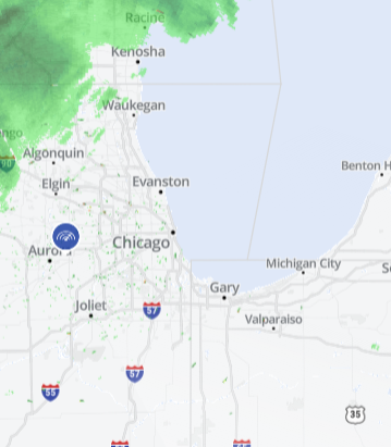
A dense fog advisory has been issued for parts of central, north central and northeast Illinois on Saturday, the National Weather Service announced.
The advisory, which ends at noon on Sunday, warns of "dense fog" leading to potentially hazardous driving conditions due to low visibility.
"Below freezing temperatures and fog may lead to slippery spots on untreated elevated surfaces," the National Weather Service said.
The following counties are included in the advisory: Winnebago, Boone, McHenry, Ogle, Lee, DeKalb, Kane, La Salle, Kendall, Grundy and Livingston.
The advisory notes the following cities are included in the warning: Rockford, Belvidere, Crystal Lake, Algonquin, McHenry, Woodstock, Rochelle, Oregon, Byron, Dixon, DeKalb, Sycamore, Aurora, Elgin, Ottawa, Streator, La Salle, Mendota, Marseilles, Oswego, Yorkville, Plano, Morris, Coal City, Minooka, Pontiac, Dwight and Fairbury.
The National Weather Service warned drivers to slow down, use headlights and leave distance ahead of the vehicle.
On Saturday, the National Weather Service said the following areas are under a limited snow risk and an elevated fog risk: Winnebago, Boone, McHenry, Lake (Illinois), Ogle, Lee, DeKalb, Kane, DuPage, La Salle, Kendall, Grundy, Kankakee, Livingston, Iroquois, Ford, Northern Cook, Central Cook, Southern Cook, Northern Will, Lake (Indiana), Porter, Newton, Jasper and Benton.
Local
Saturday will likely remain dry with patches of fog and mist making its way through the area. Cloudy skies should remain into the evening.
Temperatures remain fairly average for this time of year with Saturday highs in the mid to low 30s.
Saturday night into Sunday morning, a mix of snow and rain is expected to return with more accumulation likely in areas south of Chicago and northwest Indiana. Some areas could see around two inches of snowfall overnight.
Snow could continue through Sunday morning, making its way east by the afternoon hours and bringing drier conditions for the remainder of the day. Clouds could clear for partly sunny skies by Sunday evening.
Dry and quiet conditions will likely continue to start the week with Monday and Tuesday expected to see a mix of clouds and sunshine, but no rain nor snow.
The next chance for a winter storm is Wednesday bringing a mix of snow and rain.
