

EDITOR'S NOTE: Stay tuned to our live blog for all the latest weather information.
The National Weather Service is warning northern Illinois residents to seek shelter Tuesday afternoon as a series of severe thunderstorms march across the area, with some producing baseball-size hail and winds in excess of 70 miles per hour.
According to the National Weather Service, hail 2.75 inches in diameter is considered “baseball-size,” while hail that is 2.5 inches in diameter is considered “tennis ball-size.”
At least one report has already come in of baseball-size hail in the area, with a hailstone in Sandwich, located in DeKalb County, measuring 2.75 inches, according to trained weather spotters.
Feeling out of the loop? We'll catch you up on the Chicago news you need to know. Sign up for the weekly Chicago Catch-Up newsletter here.
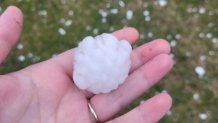
Large hail was observed in Montgomery, with golf-ball size hail falling there, as seen in an image sent to NBC 5 by viewer Amanda Sipin:
Another hailstone 2.5 inches in diameter was reported in LaSalle County’s Leland area, and a similar-sized hailstone was reported in Troy Grove, also in LaSalle County.
Local

Elsewhere, golf ball-size hail of 1.75 inches in diameter was reported in both Kane and Kendall counties, in Aurora and Yorkville, respectively.
Montgomery also reported golf ball-size hail, as did Mendota, according to officials.
The storms capable of producing the large hail are still churning toward the city of Chicago and surrounding suburbs, with a severe thunderstorm watch remaining in effect until 3 p.m.
Even more severe weather could occur later in the evening hours, according to officials, but no watches are currently in effect beyond the 3 p.m. hour at this time.
