
The National Weather Service issued a “special weather statement” Monday, warning residents that conditions are favorable for the development of funnel clouds across parts of the Chicago area.
As isolated showers and thunderstorms spark severe storm warnings for several counties, the weather service warned that funnel clouds may be seen, particularly in areas west of Interstate 39.
"The chance for these funnel clouds to make contact with the ground is low," the alert states. "Seek shelter as these isolated thunderstorms approach."
Already Monday afternoon, storms prompted thunderstorm warnings in Kendall, Will and Cook counties in Illinois and Lake County in northwest Indiana. The storms brought with them the threat of torrential rainfall and hazardous wind gusts of up to 60 mph.
Feeling out of the loop? We'll catch you up on the Chicago news you need to know. Sign up for the weekly Chicago Catch-Up newsletter here.
"Torrential rainfall is occurring with this storm, and may lead to flash flooding," the National Weather Service said. "Do not drive your vehicle through flooded roadways."
Officials say that the NWS will continue to monitor the situation, and will issue watches or warnings if conditions change.
According to doppler-indicated estimates, rainfall totals since Thursday range from between 1 and 2 inches in far northern counties and between 3 and more than 5 inches across much of the metro area and northwest Indiana.
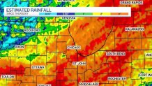
A flash flood watch continues through 7 p.m. Tuesday for most of the area, including northwest Indiana, with the exception of Lake (Illinois), McHenry and DeKalb, which have seen less rain and experienced the worst drought conditions.
Local


There likely will be dry hours in between clusters of thunderstorms in the next 48 hours as waves move from the southwest to northeast, but these storms are capable of producing torrential downpours in excess of an inch per hour.
The threat for severe weather remains low with a low-end potential for wind gusts up to 60 mph. The area is currently in a marginal risk on Tuesday.
