
Although spring began earlier this week, part of the Chicago area is being dealt a late-season winter storm, with significant snow accumulations affecting areas northwest of the city.
Both a winter storm warning and winter weather advisory went into effect for portions of the Chicago area starting Saturday morning, bringing accumulating, wet snow and gusty winds to north suburban communities.
Lake and McHenry counties will likely be among the hardest hit, with a winter system dumping up to 2 inches of snow per hour and accumulations possibly exceeding 9 inches when all is said and done.
Accumulations up to 10 inches are possible in Kenosha County, Wisconsin.
Feeling out of the loop? We'll catch you up on the Chicago news you need to know. Sign up for the weekly Chicago Catch-Up newsletter here.
Here's what we know about the arrival of the weather system, what you should expect and when.
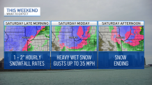
Late Saturday Morning/Midday
Lake and McHenry counties will likely see the most accumulation, with snowfall rates of up to 2 inches per hour through the late morning hours, according to NBC 5 Storm Team Chief Meteorologist Brant Miller.
Local

Sporadic power outages and downed tree limbs are possible, as well, due to the combination of heavy snow and gusty winds of up to 35 miles per hour, according to the NWS. Kenosha County will likely see much of the same, but could experience higher snowfall totals. Accumulations between 6 and 10 inches are expected there, according to NWS.
In northern Cook County, a winter weather advisory went into effect at 7 a.m., warning of snowfall rates in excess of one inch during a brief period in the morning.
DeKalb and Kane counties, meanwhile, will likely experience snowfall rates of somewhere between 1 and 2 inches per hour. Slushy snow will likely cover untreated roads, making driving conditions challenging there as well.
Saturday Afternoon
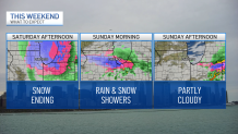
While both the winter storm warning and winter weather advisory are set to expire at 1 p.m., the snow won't stop immediately. Snow will possibly mix with rain after 1 p.m., then gradually end in the hours after that.
By then, Lake and McHenry counties will likely have seen somewhere between 5 and 9 inches of snow. DeKalb and Kane counties might experience anywhere between 2 to 8 inches of snowfall, according to the NWS. Meanwhile, northern portions of DuPage, Kendall and LaSalle counties could see as much as 2 to 4 inches of snow, while southern portions may only experience little accumulation, if any.
Saturday Night
Partly cloudy skies will be present across most of the region Saturday night. Conditions will likely be chilly, with low temperatures in the mid to high 20s and wind gusts of up to 20 miles per hour.
Sunday
Temperatures will start out in the upper 20s with partly cloudy skies at the start of the Bank of America Shamrock Shuffle. While conditions are likely to stay dry and chilly throughout the duration of the race, rainfall is expected to impact the area beginning in the midday hours.
Highs are expected to reach the low 40s, closing another weekend with unseasonably cool temperatures.
