
A cold front approaching the Chicago area generated showers and thunderstorms, with a severe thunderstorm warning and power outages occurring as a result of those storms.
Here's how the storms unfolded in real-time:
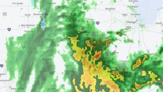
A line of thunderstorms swept through the Chicago area on Wednesday afternoon, bringing with it heavy rain and gusty winds that left nearly 4,000 utility customers without power.
According to ComEd, at least 3,500 customers were left without power as of 6 p.m. Wednesday due to high winds and severe storms that swept through the area.
Feeling out of the loop? We'll catch you up on the Chicago news you need to know. Sign up for the weekly Chicago Catch-Up newsletter here.
A cold front propelling the storms is expected to bring cooler-than-average temperatures along with it late Wednesday, but the winds will likely stick around even after the system departs the region, with a wind advisory remaining in effect through Thursday evening.
The line of storms didn’t pack the severe punch that some initial forecasts had predicted, with showers and storms during the morning hours likely stabilizing the atmosphere, but there was one severe thunderstorm warning that was issued in parts of Kendall and Will counties.
That storm cell created wind gusts of nearly 60 miles per hour, knocking over a semi-trailer in Wilton Center and knocking down tree branches in other locations, according to the National Weather Service.
Local

After the storm system moves out of the region, it will leave behind cooler-than-average temperatures and partly-to-mostly cloudy skies in coming days. Thursday will see wind gusts in excess of 30 miles per hour, along with high temperatures in the low-to-mid 50s across the region.
Friday will still see mostly cloudy skies, with temperatures rising into the mid-to-upper 50s before another cooldown leaves temperatures in the 40s in some locations over the weekend.
4:45 p.m.: Wind Gusts in Excess of 50 MPH Reported in Will County
A special weather statement has been issued for Lake, Kane, DuPage and Cook counties through 5:30 p.m., with wind gusts in excess of 50 miles per hour and heavy rain heading toward the area.
The wind and rain could potentially cause serious issues during the evening commute, and travel on east-west roadways could be impacted, especially for high-profile vehicles.
Throughout the area, wind gusts in excess of 50 mph have been reported. Here are some of the top gusts so far:
Manhattan (Will County) - 58 mph
Peotone (Will County) - 51 mph
Plainfield (Will County) - 55 mph
4:22 p.m. Severe Thunderstorm Warning Issued for Parts of 3 Counties
A severe thunderstorm warning has been issued for parts of DuPage, Kendall and Will counties until 4:45 p.m., according to the National Weather Service.
According to the alert, northeastern Kendall County, northwestern Will County and central DuPage County are impacted by the warning.
A severe thunderstorm, located over Plainfield, is moving toward the northeast at 50 miles per hour, packing wind gusts of up to 60 miles per hour.
The high winds could damage roofs, siding and trees, and could cause power outages.
3:45 p.m. Special Weather Statement Issued for Several Illinois Counties
A special weather statement has been issued for several counties in the southern portion of the NBC 5 viewing area, with isolated wind gusts of up to 50 miles per hour and heavy rain possible in coming hours.
The statement impacts southern Kendall County, east-central LaSalle County, southwestern Will County, and all of Grundy and Kankakee counties, and will last through 4:30 p.m.
A line of storms stretching from Streator to Dwight and all the way down to Ashkum are set to sweep through the area, moving toward the northeast at 45 miles per hour.
3:17 p.m. Stormy Weather Expected in Chicago Soon
According to NBC 5 Storm Team meteorologist Paul Deanno, showers and thunderstorms are currently racing toward the city of Chicago, and could pack a wallop as they move through.
Heavy rain is possible with the storms, which are moving toward the northeast in excess of 40 miles per hour.
Wind gusts of 50 miles per hour or more are already being reported in some locations, and gusts could increase if the storms begin to intensify.
An isolated tornado also cannot be ruled out, especially to the south of Interstate 80.
3:14 p.m. Special Weather Statement Issued for LaSalle County
While no severe storms are currently threatening the Chicago area, some intense thunderstorms are beginning to arrive in the far southern counties, prompting the National Weather Service to issue a “special weather statement.”
That statement impacts southern LaSalle County through 3:45 p.m.
A strong thunderstorm, located near Wenona and approximately 13 miles to the west of Streator, is moving toward the northeast at 40 miles per hour, packing wind gusts in excess of 50 miles per hour.
The storm could impact Buffalo Rock, Matthiessen and Starved Rock state parks as it travels through the area.
Residents are urged to secure loose objects outside, and to seek shelter inside a building if at all possible.
2:09 p.m. Wind Advisory Issued Ahead of Possible Severe Weather
One of the main threats associated with a cold front sweeping through the Chicago area is damaging straight-line wind, and the National Weather Service has issued a wind advisory through Thursday evening.
That advisory includes McHenry, Lake, DeKalb, Kane, DuPage, Cook, LaSalle, Kendall, Grundy, Will and Kankakee counties in Illinois, as well as Lake, Porter, LaPorte, Newton and Jasper counties in northwest Indiana, and will run through 7 p.m. Thursday.
Wind gusts in excess of 50 miles per hour are possible, both during a potential severe weather outbreak and also during the day on Thursday, with winds continuing even on the back side of a cold front that’s impacting the region.
Residents are asked to secure loose objects outside, and warned that travel may be challenging on east-west roadways because of the high winds.
12:05 p.m. Flash Flood Watch Issued for the Illinois River
A flash flood watch has been issued for the Illinois River in the La Salle, Bureau and Putnam zones, forecasters say.
Based on precipitation the area has received, and is expected to get in coming hours, the river could rise above flood stage in coming days.
